Updated 9/6/2023 6:16 PM
The latest from InciWeb as of 9/5/2023 6:46 PM CST
Incident Information
| Current as of | Tue, 09/05/2023 - 18:46 |
|---|---|
| Incident Type | Wildfire |
| Cause | Undetermined |
| Date of Origin | Fri, 09/01/2023 - 14:00 |
| Location | The fire is located approximately 9.5 miles northwest of Huntsville, TX. |
| Incident Commander | Bryce Thomas, Florida Forest Service Red CIMT Wayne Rushing, Florida Forest Service Red CIMT |
| Coordinates | 30° 51' 21'' Latitude -95° 37' 40 '' Longitude |
| Total Personnel: | 110 |
|---|---|
| Size | 4,428 Acres |
| Percent of Perimeter Contained | 85% |
| Estimated Containment Date | 09/10/2023 |
| Fuels Involved | Timber with medium logging slash. |
| Significant Events | Observed Fire Behavior or Significant Events for the Time Period Reported (describe fire behavior using accepted terminology. For non-fire incidents, describe significant events related to the materials or other causal agents): Moderate Single Tree Torching Spotting Smoldering Narrative: Current fire behavior is fuel driven. Fire threat still remains within fireline boundary. Relative humidity values and extended drought have left fuel moistures in critical levels. Continued moderate fire behavior is expected over the next few days. |
| Planned Actions | Continue establishing containment lines on all of the fire perimeter and establish mop up operations. |
|---|---|
| Projected Incident Activity | As of 6 p.m. September 3, 202312 hours: Fire is 1/4 mile to the East of I-45 with moderate potential for movement.24 hours: Low to moderate potential for movement.48 hours: Low to moderate potential for movement.72 hours: Low to moderate potential for movement.Anticipated after 72 hours: Low to moderate potential for movement. |
| Weather Concerns | TODAY: Afternoon relative humidity values will remain elevated today due to persistent onshore flow. These relative humidity values will range from 30 to 40 percent over our northern and western counties to 50 to 70 percent over our southern and coastal counties. There will also be a chance of isolated to scattered showers and thunderstorms today with a lower chance of showers and storms tomorrow. Despite these rain chances, ground fuels are expected to remain quite dry through the forecast period. FORECASTED: By mid-week, the trend of higher humidity will end as afternoon shower and storm coverage decreases, and high temperatures drift upwards. Late in the week, look for the trend to reverse to decreasing RH values with the arrival of some drier air. |
|---|
Updated 9/4/2023 10:24 AM
ABC13 Television posted an update on the fire earlier today
WALKER COUNTY, Texas (KTRK) -- Firefighters are still working to prevent a wildfire in Walker County from spreading. The firefighting efforts entered day four on Monday.
In a 5 p.m. on Sunday, the Game Preserve Fire, north of Huntsville, was burning at 4,428 acres, the Texas A&M Forest Service said. The wildfire is now 60% contained.
There has been significant improvement. Just a few days ago, the fire was only 10% contained.
Read the full article: https://abc13.com/texas-wildfire-forest-fire-burning-in-walker-county-game-preserve-huntsville-what-is-near/13734596/
Updated 9/3/2023 10:00 PM
At approximately 2:00 pm on September 1, 2023, Texas A&M Forest Service received a request for a fire on Lost Indian Camp Road off State Highway 247, 9 miles northwest of Huntsville, Texas. The fire is actively burning in pine timber with grass and yaupon understory. Elevated fire weather, including low relative humidity and winds out of the East are supporting high fire behavior where dry vegetation is present on the fire.
At 8:00 a.m. on September 3, Florida Forest Service Red Complex Incident Management Team assumed command of the Game Preserve Fire. The team had been pre-positioned in Texas to be able to respond and assist with incidents as needed. This team will manage the fire with resources from local fire departments, Texas A&M Forest Service, Texas Intrastate Fire Mutual Aid System (TIFMAS), and Texas Emergency Medical Task Force (TEMTF).
As of 8:30 a.m. on September 3, all evacuation orders and road closures for the Game Preserve Fire have been lifted. Fire managers and local officials will continue to monitor the fire to ensure safety for all residents and public.
On September 3, dozers will work to install a line next to the Cedar Ridge neighborhood. Fixed wing aircraft will work to put retardant in this area as well.
There is a Temporary Flight Restriction (TFR) in place for the area over the fire, this was updated 9/2/23 [NOTAM: FDC 3/4932, https://bit.ly/3qWdnHY ]. Please avoid the area to provide a safe environment for firefighting aircraft. Please avoid the area to provide a safe environment for incoming firefighting aircraft.
Incident Information
| Current as of | Sun, 09/03/2023 - 20:32 |
|---|---|
| Incident Type | Wildfire |
| Cause | Undetermined |
| Date of Origin | Fri, 09/01/2023 - 14:00 |
| Location | The fire is located approximately 9.5 miles northwest of Huntsville, TX. |
| Incident Commander | Bryce Thomas, Florida Forest Service Red CIMT Wayne Rushing, Florida Forest Service Red CIMT |
| Coordinates | 30° 51' 21'' Latitude -95° 37' 40 '' Longitude |
| Total Personnel: | 110 |
|---|---|
| Size | 4,428 Acres |
| Percent of Perimeter Contained | 60% |
| Estimated Containment Date | 09/10/2023 |
| Fuels Involved | Timber with medium logging slash. |
| Significant Events | The fire is exhibiting moderate fire behavior with group tree torching and fire spotting. The current fire behavior is fuel driven. Today (9/3), the fire made short runs and impacted control lines. Low relative humidity values and extended drought have left fuel moistures in critical levels and continued moderate fire behavior is expected over the next few days. |
| Planned Actions | Continue establishing containment lines on all of the fire perimeter and establish mop up operations. |
|---|---|
| Projected Incident Activity | As of 6 p.m. September 3, 202312 hours: Fire is 1/4 mile to the East of I-45 with moderate potential for movement.24 hours: Low to moderate potential for movement.48 hours: Low to moderate potential for movement.72 hours: Low to moderate potential for movement.Anticipated after 72 hours: Low to moderate potential for movement. |
| Weather Concerns | Sunday: High temperatures of 99 degrees are expected today with southwest morning winds to southeast evening winds reaching 7 mph. This southerly flow will persist through Sunday with gusts to 10 to 15 mph possible in the afternoon. There is a 30% chance for isolated showers and thunderstorms popping up over the region tomorrow that could produce variable, gusty winds near the storms. Mixing heights will rise through the day to over 9000 ft. Relative humidity values tomorrow will be higher with values in the 35 to 40% range during the afternoon. Monday: High Temperatures of 97 degrees are expected tomorrow with southerly morning winds changing to south-easterly and reaching 9 mph. There is a 40% chance for showers and storms increase as moisture continues to increase along with breezier southeasterly winds in the afternoon hours. Storms may come close enough to cause erratic, gusty outflow winds and pose threats from lightning strikes even if the fire does not receive rain. |
|---|
Updated 9/2/2023 9:20 PM
From InciWeb:
Incident Information
| Current as of | Sat, 09/02/2023 - 16:51 |
|---|---|
| Incident Type | Wildfire |
| Cause | Undetermined |
| Date of Origin | Fri, 09/01/2023 - 14:00 |
| Location | The fire is located approximately 9 miles northwest of Huntsville. |
| Incident Commander | J. Russell, Texas A&M Forest Service, in coordination with local officials |
| Coordinates | 30° 51' 21'' Latitude -95° 37' 40 '' Longitude |
| Total Personnel: | 171 |
|---|---|
| Size | 3,800 Acres |
| Percent of Perimeter Contained | 20% |
| Estimated Containment Date | 09/08/2023 |
| Fuels Involved | Timber with medium logging slash. |
| Significant Events | The fire is exhibiting extreme fire behavior with crowning, group tree torching and fire spotting. This is a fuel driven fire. |
| Planned Actions | Conduct structure protection while dozers create containment line, continue to use air resources. |
|---|---|
| Projected Incident Activity | 12 Hours - Voluntary evacuations are currently underway with Walker County OEM. Highway 247 is shut down. The fire is about 1 mile from I-45 with dry fuel in front of an actively moving fire.24 hours - Evacuations and road closures. |
Updated 9/2/2023 2:59 PM
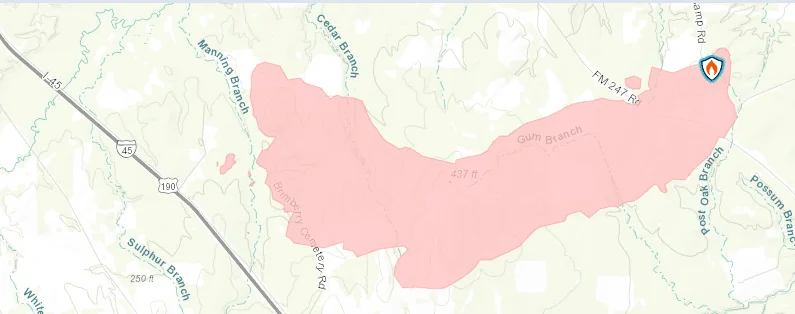
The latest update on InciWeb shows the updated map, and the size has increased to 3,800 acres with 20% containment. Click here for the latest.
Updated 9/2/2023 10:51 AM
Article from Brenda Poe at the Huntsville Item, posted shortly after 10:45 AM CST 9/2/2023
FULL ARTICLE: https://www.itemonline.com/news/fire-only-20-percent-contained-burned-3-000-acres/
Updated 9/2/2023 10:45 AM
From State Representative Kyle Kacal's Facebook Page:
Update:
The Game Preserve Fire is still reported at 3,000 acres but now at 20% containment according to an update provided to us by TDEM.
Heavy aircraft and dozer operation started this morning. Additional ground assets are being sent to the Cedar Ridge Road area for structure protection.
IH-45 was reopened this morning.
Service road from FM 1696 to FM 2989 will be closed by TXDOT supported by Walker County SO.
Please consider following the Walker County OEM Facebook page, if you haven’t done so already, for current information on evacuations, donations, or emergent needs. And please continue to pray for all of our first responders and those affected by this fire.
Updated 9/2/2023 10:35 AM
Game Preserve Fire Daily Update: September 2, 2023 (From InciWeb)
Game Preserve Fire
News - 09/02/2023
Game Preserve Fire Daily Update
September 2, 2023
10:00 am
Size: 3,000 acres
Containment: 10%
Start Date: September 1, 2023
Cause: Under Investigation
On September 1, 2023, Texas A&M Forest Service received a request for a fire on Lost Indian Camp Road off State Highway 247, 9 miles northwest of Huntsville, Texas. The fire continues to actively burn in pine timber with grass and yaupon understory.
Overnight, crews from Texas A&M Forest Service and local fire departments engaged in suppression efforts with constructing dozer lines. Fire activity continued through the night causing further evacuations and a temporary road closure on Interstate 45.
Local and state crews are back on scene today with fresh resources. Multiple pieces of heavy equipment and engines continue to build containment lines along the fire perimeter and improve existing containment lines. Two Texas Intrastate Fire Mutual Aid System (TIFMAS) engine strike teams are providing structure protection for those near the fire perimeter including Cedar Ridge subdivision. Aviation resources have been requested and are on scene to slow forward progression towards Interstate 45 (I-45). Additional resources continue to enter the area to preposition and assist for this afternoon.
Weather:
Upper trough continues to dig into the northern Gulf of Mexico and will therefore introduce more dry air into the region. The current weather pattern of below 30 percent relative humidity levels and northwesterly winds ranging between 5-10 mph, with occasional gusts up to 15 mph will remain in place.
Evacuations:
Evacuations were ordered for all residents within 3 miles of Lost Indian Camp Road. As the evening progressed, growth from the fire prompted additional evacuations from Cedar Ridge subdivision. All evacuation orders remain in place. Residents being evacuated should take all people and pets, personal items, prescriptions, important papers, and priceless items with them. Have enough of these necessary items to be out of the area for 24-48 hours.
Closures:
Portions of State Highway 247 are currently closured from farm to market road (FM) 2628 to FM 2989. Last night, the growth of the fire caused Interstate 45 (I-45) to temporarily close. I-45 is currently open. Additional information on road closures in the area can be found on www.drivetexas.org.
Damages and Injuries:
Currently, there have been no reports of injuries from the public or first responders. No structure or critical infrastructure have been lost.
Incident Overview (From InciWeb)
At approximately 2:00 pm on September 1, 2023, Texas A&M Forest Service received a request for a fire on Lost Indian Camp Road off State Highway 247, 9 miles northwest of Huntsville, Texas. The fire is actively burning in pine timber with grass and yaupon understory.
Elevated fire weather, including low relative humidity and winds out of the East are supporting high fire behavior where dry vegetation is present on the fire.
In coordination with local fire departments, state resources from Texas A&M Forest Service and Texas Intrastate Fire Mutual Aid System (TIFMAS) as well as several aviation resources are engaged in suppression efforts. Multiple dozers are constructing containment lines on the fire with engine support from local fire departments. Multiple helicopters and fixed-winged aircraft are working to slow the fire’s forward progression and provide structure protection.
Portions of State Highway 247 are currently closured from farm to market road (FM) 2628 to FM 2989. Additional information on road closures in the area can be found on www.drivetexas.org.
Evacuations have been ordered for all residents within 3 miles of Lost Indian Camp Road. Residents being evacuated should take all people and pets, personal items, prescriptions, important papers, and priceless items with them. Have enough of these necessary items to be out of the area for 24-48 hours.
There is a Temporary Flight Restriction (TFR) in place for the area over the fire [NOTAM: FDC 3/4873, https://bit.ly/3OZVzE2 ]. Please avoid the area to provide a safe environment for firefighting aircraft. Please avoid the area to provide a safe environment for incoming firefighting aircraft.
Incident Information (From InciWeb)
| Current as of | Sat, 09/02/2023 - 11:17 |
|---|---|
| Incident Type | Wildfire |
| Date of Origin | Fri, 09/01/2023 - 14:00 |
| Location | The fire is located approximately 9 miles northwest of Huntsville. |
| Incident Commander | J. Russell, Texas A&M Forest Service, in coordination with local officials |
| Coordinates | 30° 51' 21'' Latitude -95° 37' 40 '' Longitude |
| Total Personnel: | 53 |
|---|---|
| Size | 3,000 Acres |
| Percent of Perimeter Contained | 10% |
| Fuels Involved | Timber with grass and understory |
Original News Story
Walker County, Texas—Homes north of Huntsville were evacuated as a wildfire, dubbed the Game Preserve Fire, expanded rapidly, burning 3,000 acres as of Saturday morning.
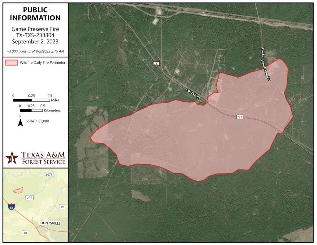
The Walker County Office of Emergency Management reported that the fire initially broke out Friday afternoon near Lost Indian Camp Road off FM-247. From its start at 100 acres at 4:21 p.m., the fire escalated to 500 acres by 5:27 p.m. and 1,000 acres by 7:37 p.m.
By 9 p.m. Friday, the Texas A&M Forest Service stated that the fire covered 1,200 acres and was 10% contained. Early Saturday, containment remained at 10%, but the fire's span had grown to 3,000 acres. As of 8:30 a.m. Saturday, the fire was 20% contained.
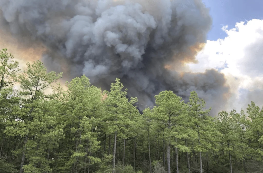
Officials have not yet determined the cause of the fire, but note that drought conditions are contributing to its rapid spread. An evacuation was recommended within a three-mile radius of Lost Indian Camp Road, and a separate evacuation order was issued for residents of Pinedale by the New Waverly Fire Department.
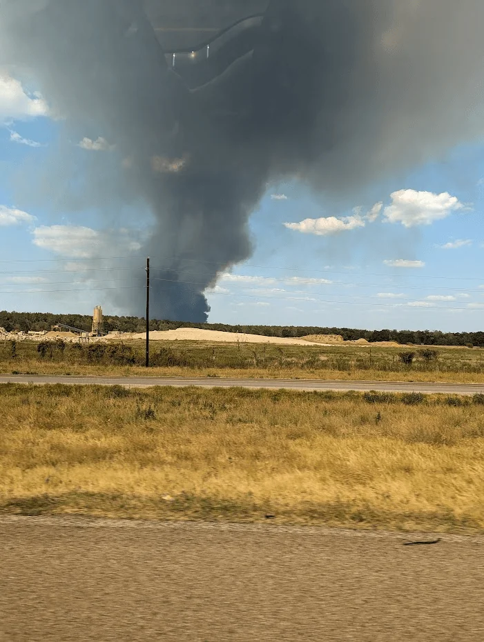
A 6.5-mile stretch of FM-247, from FM-2989 to Pinedale Road, has been closed due to the fire.
Despite the rural location, homes and farmland are at risk. Voluntary evacuations are in place for those in the fire's path. The Walker County government had previously instituted a burn ban on July 31, restricting most outdoor ignitions.
Related Links:
InciWeb the Incident Information System - Latest Game Preserve Wildfire Updates
FIRMS US/ CANADA - Fire Information for Resource Management System


