


Continious Updates on the January 2024 Arctic Blast: Huntsville Prepares as Arctic Blast Brings Prolonged Cold Stretch
Updated 1/15/2024
The arctic air mass has fully settled over our region, leading to slick roads caused by freezing fog and mist. There have been isolated reports of light sleet and snow flurries. The chance for precipitation is slim, continuing into early evening, with skies expected to clear overnight. Temperatures will plummet to the upper teens overnight, and highs are unlikely to surpass the freezing mark tomorrow. Freezing conditions will persist through Tuesday night, with lows again in the upper teens. Temperatures are forecast to rise above freezing on Wednesday, reaching the upper 40s. The National Weather Service has issued a Winter Weather Advisory for the area until 6 p.m. today, a Wind Chill Warning until noon tomorrow, and a Hard Freeze Warning until 9 a.m. on Wednesday, Jan. 17.
Wind Chill Warning
URGENT - WINTER WEATHER MESSAGE
National Weather Service Houston/Galveston TX
124 PM CST Mon Jan 15 2024

TXZ163-164-176-177-195>198-160330-
/O.UPG.KHGX.WC.Y.0002.240116T0000Z-240116T1800Z/
/O.NEW.KHGX.WC.W.0001.240115T1924Z-240116T1800Z/
/O.CON.KHGX.WW.Y.0001.000000T0000Z-240116T0000Z/
Houston-Trinity-Madison-Walker-Burleson-Brazos-Washington-Grimes-
Including the cities of Crockett, Trinity, Groveton,
Madisonville, Huntsville, Caldwell, Somerville, College Station,
Bryan, Brenham, and Navasota
124 PM CST Mon Jan 15 2024

...WIND CHILL WARNING IN EFFECT UNTIL NOON CST TUESDAY...
...WINTER WEATHER ADVISORY REMAINS IN EFFECT UNTIL 6 PM CST THIS
EVENING...

* WHAT...For the Wind Chill Warning, dangerously cold wind chills.
  Wind chills as low as 5 degrees below zero. For the Winter
  Weather Advisory, mixed precipitation. Total ice accumulations
  of up to one tenth of an inch.

* WHERE...Portions of southeast Texas.

* WHEN...For the Wind Chill Warning, until noon CST Tuesday. For
  the Winter Weather Advisory, until 6 PM CST this evening.

* IMPACTS...Very slippery sidewalks, roads and bridges are
  possible. There have been multiple reports of ice accumulating
  on roadways north of I-10 today. These hazardous conditions
  could impact the morning or evening commute.

* ADDITIONAL DETAILS...Total ice accumulations of up to one tenth
  of an inch may result in icy patches on elevated roadways such
  as bridges and overpasses.

PRECAUTIONARY/PREPAREDNESS ACTIONS...

Avoid outside activities if possible. When outside, make sure you
wear appropriate clothing, a hat, and gloves.

Slow down and use caution while traveling. Prepare for possible
power outages.

The latest road conditions for the state you are calling from can
be obtained by calling 5 1 1.
Hard Freeze Warning
URGENT - WEATHER MESSAGE
National Weather Service Houston/Galveston TX
118 PM CST Mon Jan 15 2024

TXZ163-164-176>179-195>200-210>214-226-227-235>238-300-313-160330-
/O.EXT.KHGX.HZ.W.0002.240115T1918Z-240117T1500Z/
Houston-Trinity-Madison-Walker-San Jacinto-Polk-Burleson-Brazos-
Washington-Grimes-Montgomery-Northern Liberty-Colorado-Austin-
Waller-Inland Harris-Chambers-Wharton-Fort Bend-Inland Jackson-
Inland Matagorda-Inland Brazoria-Inland Galveston-
Southern Liberty-Coastal Harris-
Including the cities of Crockett, Trinity, Groveton,
Madisonville, Huntsville, Shepherd, Coldspring, Livingston,
Corrigan, Caldwell, Somerville, College Station, Bryan, Brenham,
Navasota, Conroe, The Woodlands, Liberty, Cleveland, Dayton,
Columbus, Eagle Lake, Weimar, Sealy, Bellville, Hempstead,
Prairie View, Brookshire, Waller, Houston, Winnie, Mont Belvieu,
Anahuac, Stowell, Old River-Winfree, El Campo, Wharton,
Missouri City, Mission Bend, Sugar Land, Rosenberg, First Colony,
Pecan Grove, Edna, Ganado, Bay City, Pearland, Alvin, Angleton,
League City, Friendswood, Devers, Pasadena, and Baytown
118 PM CST Mon Jan 15 2024

...HARD FREEZE WARNING NOW IN EFFECT UNTIL 9 AM CST WEDNESDAY...

* WHAT...Sub-freezing temperatures as low as 13 degrees expected.

* WHERE...Portions of south central and southeast Texas.

* WHEN...Until 9 AM CST Wednesday.

* IMPACTS...Frost and freeze conditions will kill crops, other
  sensitive vegetation and possibly damage unprotected outdoor
  plumbing.

* ADDITIONAL DETAILS...Temperatures will climb into the low to
  mid 30s on Tuesday; however, sub freezing temperatures are
  again expected Tuesday night into Wednesday. Therefore, the
  Hard Freeze Warning will remain in effect through early
  Wednesday morning.

PRECAUTIONARY/PREPAREDNESS ACTIONS...

Take steps now to protect tender plants from the cold. To prevent
freezing and possible bursting of outdoor water pipes they should
be wrapped, drained, or allowed to drip slowly. Those that have
in-ground sprinkler systems should drain them and cover above-
ground pipes to protect them from freezing.
Updated 1/13/2024
A WINTER WEATHER ADVISORY has been issued for WALKER COUNTY and surrounding areas, and will be in effect from 6 PM SUNDAY through 6 PM MONDAY. Freezing rain mixed with sleet may lead to icy patches on elevated roadways, so be sure to exercise caution while driving.
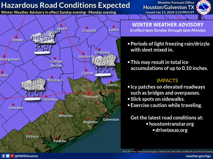
Official Advisory from the National Weather Service
URGENT - WINTER WEATHER MESSAGE
National Weather Service Houston/Galveston TX
213 PM CST Sat Jan 13 2024

TXZ163-164-176>179-195>200-210>212-140600-
/O.NEW.KHGX.WW.Y.0001.240115T0000Z-240116T0000Z/
Houston-Trinity-Madison-Walker-San Jacinto-Polk-Burleson-Brazos-
Washington-Grimes-Montgomery-Northern Liberty-Colorado-Austin-
Waller-
Including the cities of Crockett, Trinity, Groveton,
Madisonville, Huntsville, Shepherd, Coldspring, Livingston,
Corrigan, Caldwell, Somerville, College Station, Bryan, Brenham,
Navasota, Conroe, The Woodlands, Liberty, Cleveland, Dayton,
Columbus, Eagle Lake, Weimar, Sealy, Bellville, Hempstead,
Prairie View, Brookshire, and Waller
213 PM CST Sat Jan 13 2024

...WINTER WEATHER ADVISORY IN EFFECT FROM 6 PM SUNDAY TO 6 PM CST
MONDAY...

* WHAT...Freezing rain expected. Total ice accumulations of up to
  one tenth of an inch may result in icy patches on elevated
  roadways such as bridges and overpasses.

* WHERE...Portions of southeast Texas.

* WHEN...From 6 PM Sunday to 6 PM CST Monday.

* IMPACTS...Difficult travel conditions are possible. The
  hazardous conditions could impact the morning or evening
  commute.

* ADDITIONAL DETAILS...Sleet/ice pellets may mix into the freezing
  rain at times. The higher ice accumulations are expected
  generally north of SH-105 and east of I-45.

PRECAUTIONARY/PREPAREDNESS ACTIONS...

Slow down and use caution while traveling. Prepare for possible
power outages.

The latest road conditions for the state you are calling from can
be obtained by calling 5 1 1.
Updated 1/12/2024
The Houston-Galveston National Weather Office has issued a winter weather briefing. Watch below.
Original Article January 11, 2024
Huntsville, TX - Huntsville residents are gearing up for a drastic shift in weather patterns over the next few days. Thursday begins with patchy fog, expected to clear by 10 am, leading to partly sunny skies and highs nearing 72°F. A south wind at 10 to 15 mph, with potential gusts up to 25 mph, will accompany the warmth. However, as evening sets in, chances of showers and thunderstorms rise, persisting until the early hours, with skies clearing towards dawn and temperatures dropping to around 40°F. Post-midnight, winds will veer from south to west, possibly gusting up to 35 mph.
Friday's sunshine will not equate to warmth, as temperatures are predicted to drop to around 40°F by 9 am, amidst breezy conditions. The night will clear up, with lows forecasted at about 31°F. Saturday offers a brief respite with mostly sunny skies and a high around 59°F, but the mercury is set to fall again during the night to approximately 32°F.
The onset of a severe cold snap is expected on Sunday, with mostly sunny skies but a high only near 36°F. Evening conditions may include a slight chance of rain transitioning to freezing rain, with temperatures expected to nosedive to around 22°F. This marks the start of a prolonged freeze, with Huntsville anticipated to experience lows of 17°F by Monday night and daytime highs only between 30°F and 31°F through Tuesday. Conditions are expected to slightly improve by Wednesday, with sunny skies and a high near 46°F.
Extended Freeze Predicted in Huntsville
The city is preparing for a prolonged period of freezing temperatures, beginning Sunday night and lasting approximately 60 hours. The cold stretch will start with temperatures dropping to 22°F on Sunday night, followed by daytime highs lingering around 30°F to 31°F for Monday and Tuesday. Nighttime lows will sink to 17°F and 20°F, respectively. The freeze is expected to break by Wednesday, with temperatures rising above freezing to a high near 46°F. Residents are advised to prepare for this extended cold period and ensure safety and warmth.
Urgent Cold Weather Preparations Recommended
The National Weather Service in Houston is urging residents to finalize their cold weather preparations before sunset on Saturday. Key measures include insulating outdoor pipes, protecting sprinkler systems, arranging for pet safety, and helping neighbors who may need assistance.
Adherence to 4 P's of Freeze Safety Crucial
The community is reminded to follow the "4 P's" of freeze safety: People, Pets, Plants, and Pipes. Recommendations include bringing potted plants indoors or mulching them, ensuring pets and livestock are warm, and insulating exposed pipes.
Weather Forecast and Winter Safety Guidelines
As the cold front draws near, diverse weather conditions are expected. Residents are advised to stay informed, stock up on essentials, limit travel, and maintain communication lines for safety during this extreme weather event. For the latest weather updates and safety advice, visit the National Weather Service's website at weather.gov/Houston.