Final Update July 9, 1:45 PM
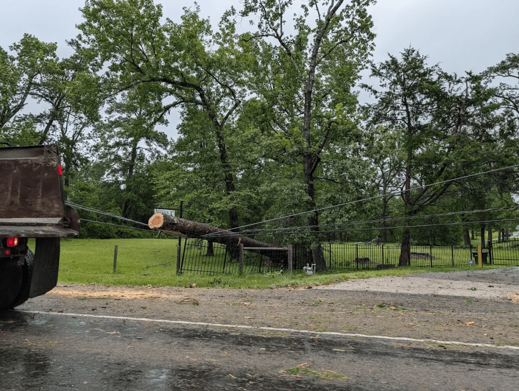
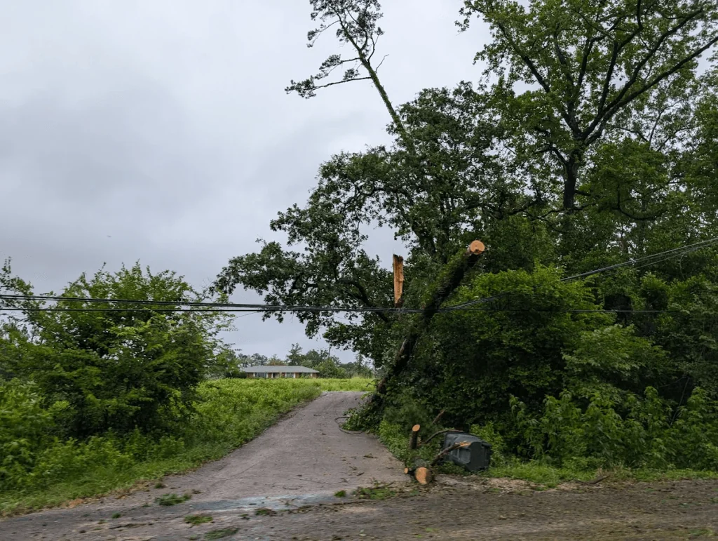
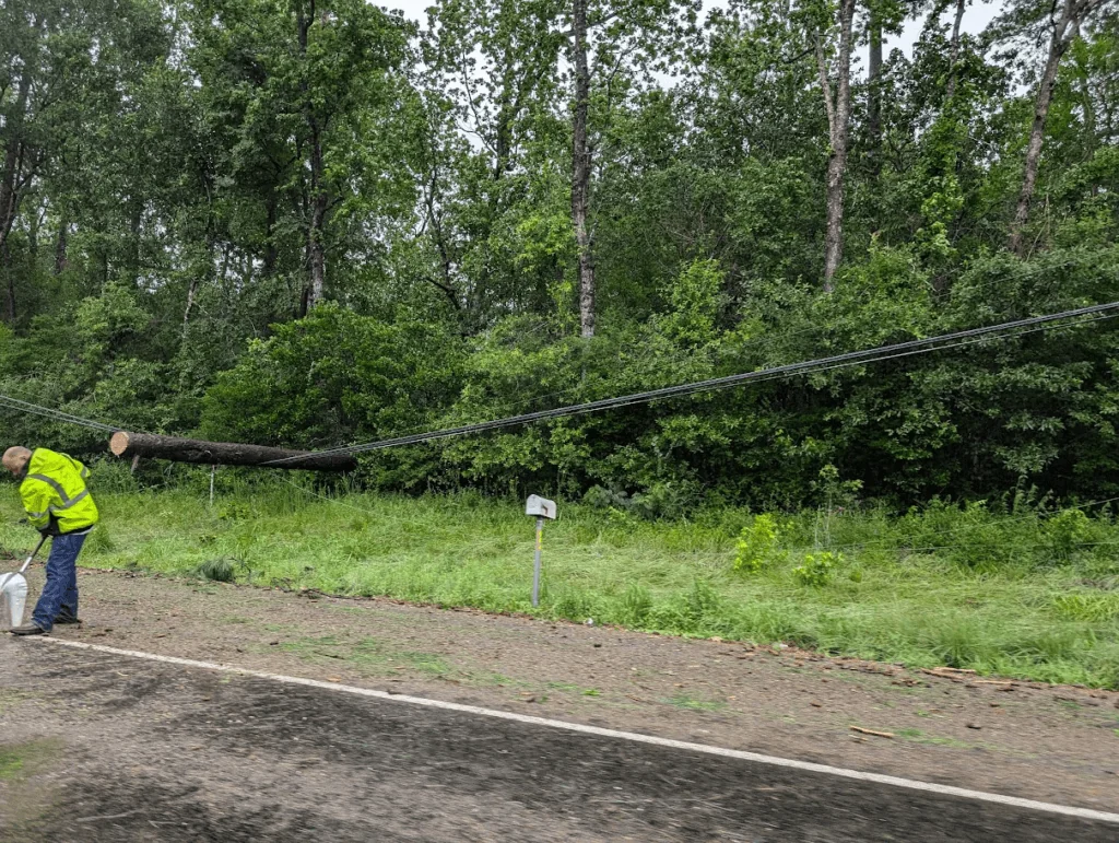
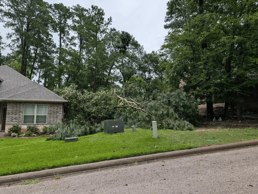
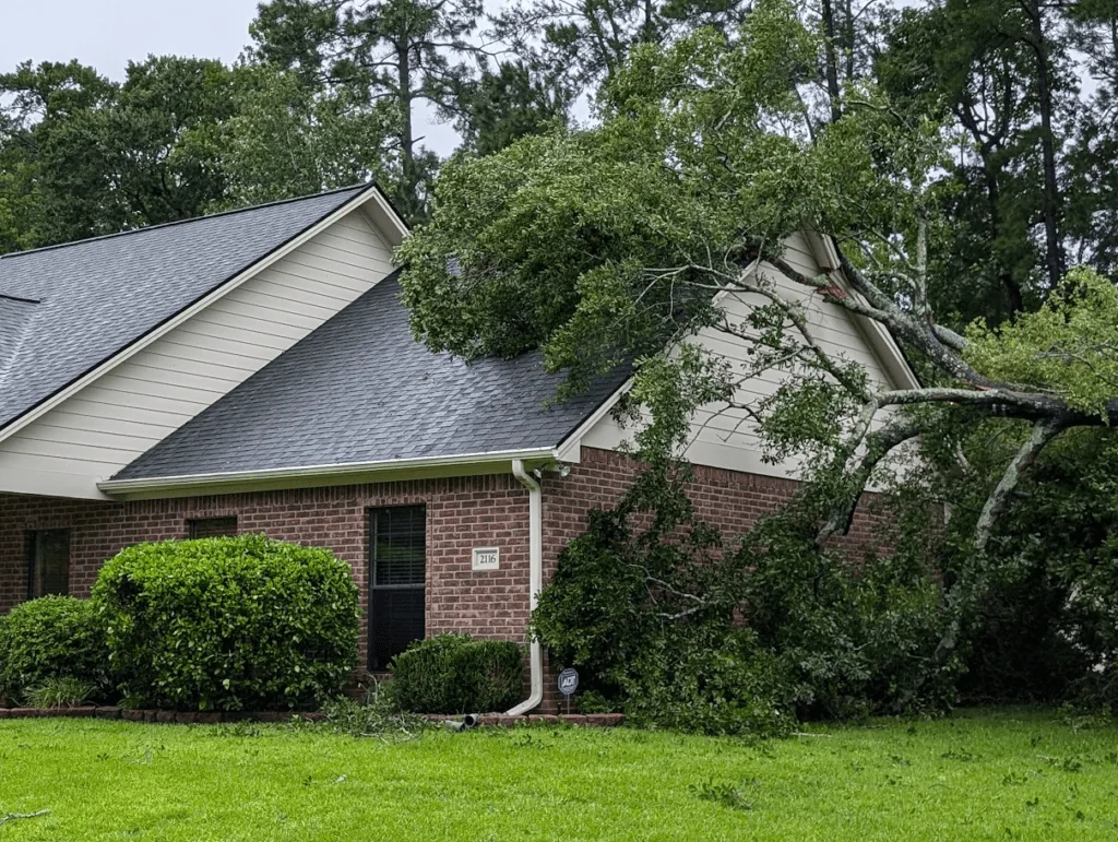
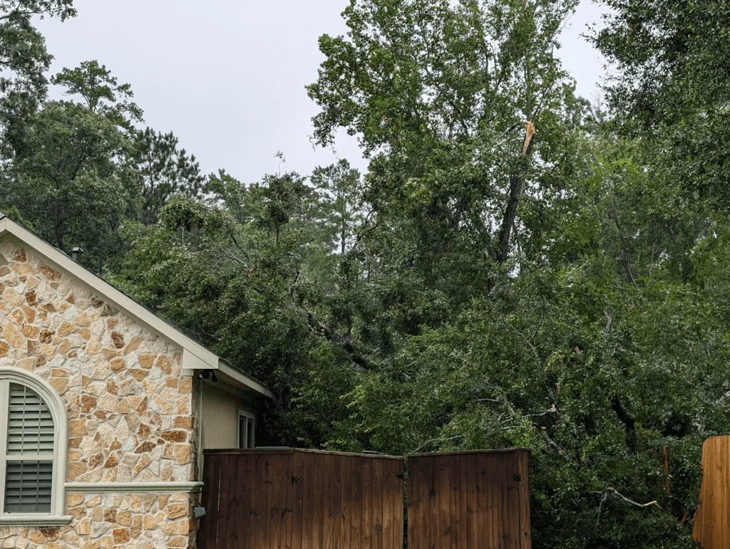
Beryl has passed through the area, leaving behind power outages, damaged lines, downed trees, and weeks of recovery. Organizations in the community are stepping up to help. Please visit our Huntsville Texas Beryl Assistance page for more resources.
This will be our final update regarding Beryl on this page. Please keep our community and those affected by the storm in your prayers, and help out where possible! #HuntsvilleStrong
Below are a few photos from the area

Updated July 8, 10:57 AM
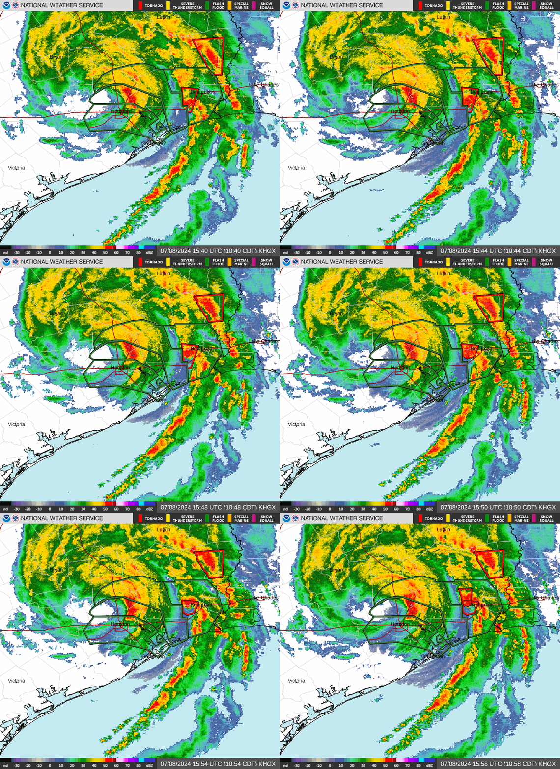
-Beryl Impacting The Area
-Flood Watch for Walker County through Tuesday Morning
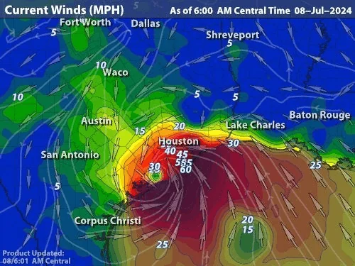
-Wind Gusts as high as 60 MPH around 1 PM Monday in Walker County Area
-Tropical Storm Warning Issued for Walker County Through Monday Afternoon
-Moderate Risk of Tornadoes
-Tornado Watch Until 10 PM Monday
-Numerous Power Outages
Beryl Downgraded to Tropical Storm: Heavy Rains and Winds Pose Main Threat
Center of circulation will pass through Huntsville (Walker County) around Noon-1PM.
Tropical Storm Beryl Tropical Cyclone Update...Corrected
NWS National Hurricane Center Miami FL       AL022024
1100 AM CDT Mon Jul 8 2024

Corrected Header

...LIFE-THREATENING STORM SURGE, DAMAGING WIND GUSTS, AND
FLOODING RAINFALL CONTINUING OVER EASTERN TEXAS...
...1100 AM CDT POSITION UPDATE...

Houston Bush Intercontinental Airport (KIAH) recently reported a
sustained wind of 59 mph (95 km/h) with a gust to 82 mph (132 km/h).

SUMMARY OF 1100 AM CDT...1600 UTC...INFORMATION
-----------------------------------------------
LOCATION...30.1N 95.6W
ABOUT 30 MI...50 KM NNW OF HOUSTON TEXAS
MAXIMUM SUSTAINED WINDS...70 MPH...110 KM/H
PRESENT MOVEMENT...NNE OR 15 DEGREES AT 13 MPH...20
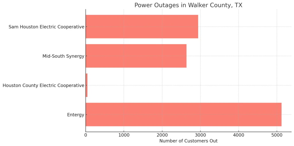
Summary of Power Outages in Walker County, TX
As of the latest update, significant power outages are affecting Walker County, TX, with a total of 10,750 customers currently without power. Here is the breakdown of outages by electric provider:
- Entergy: 5,122 customers out
- Houston County Electric Cooperative: 49 customers out
- Mid-South Synergy: 2,637 customers out
- Sam Houston Electric Cooperative: 2,942 customers out
Updated July 8, 6:23 AM
Hurricane Beryl Advisory Summary:
- Location: Near Matagorda, Texas, at 28.6N, 96.0W.
- Conditions: Dangerous storm surge, strong winds, and expected flash flooding.
- Wind Speed: Maximum sustained winds of 80 mph, with higher gusts.
- Movement: Moving north at 12 mph; expected to turn northeast with increased speed.
- Pressure: Minimum central pressure at 979 mb.
- Warnings:
- Storm Surge Warning: Mesquite Bay to Sabine Pass, including Matagorda Bay and Galveston Bay.
- Hurricane Warning: Texas coast from Mesquite Bay to Port Bolivar.
- Tropical Storm Warning: Texas coast north of Port Bolivar to Sabine Pass.
Impacts:
- Winds: Hurricane conditions along the warning areas, tropical storm conditions elsewhere.
- Storm Surge: Flooding in normally dry coastal areas, reaching 4-7 feet in some locations.
- Rainfall: 5-10 inches, locally up to 15 inches, expected in Texas; 3-5 inches in Oklahoma, Arkansas, and Missouri.
- Tornadoes: Possible in east Texas, Louisiana, and Arkansas.
- Surf: Life-threatening surf and rip currents along the Gulf Coast.
In Houston, the impacts of Hurricane Beryl are being felt intensely with gusts reaching up to 85 miles per hour, leaving 500,000 residents without power this morning. The city's infrastructure is strained as emergency services work tirelessly to address widespread outages and damages. Local news stations are urging people to stay indoors and off the roads unless absolutely necessary. As Beryl continues its northward path, the center of circulation is expected to approach the Huntsville area around noon. Huntsville can anticipate strong winds, heavy rainfall, and potential flash flooding. Residents should prepare for power outages and hazardous conditions, taking all necessary precautions to ensure their safety as the storm moves through, and follow local news stations' advice to stay indoors and off the roads.
From Huntsville Fire Department... ![]() For any non-emergency needs, please contact the Huntsville Emergency Operations Center (EOC) at 936-291-5917. Our team is here to assist you.
For any non-emergency needs, please contact the Huntsville Emergency Operations Center (EOC) at 936-291-5917. Our team is here to assist you.
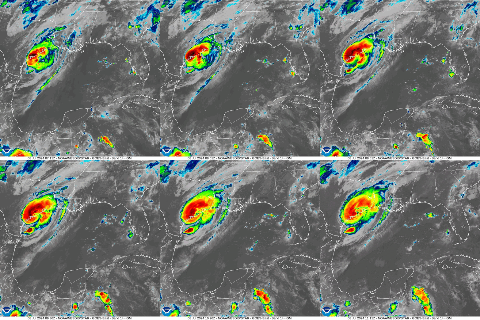
Updated July 7, 11:32 PM
Hurricane Beryl Tropical Cyclone Update
NWS National Hurricane Center Miami FL       AL022024
1100 PM CDT Sun Jul 7 2024

...BERYL IS AGAIN A HURRICANE...

Data from the National Weather Service Doppler radar near Houston,
Texas, and reports from an Air Force Reserve Hurricane Hunter
aircraft indicate that Beryl's maximum sustained winds have
increased to near 75 mph (120 km/h).  Based on these data, Beryl is
upgraded to a hurricane. Additional strengthening is expected
before landfall on the Texas coast.

NOAA buoy 42019 recently reported sustained winds of 60 mph
(97 km/h) and a wind gust of 74 mph (119 km/h).  The buoy also
reported a pressure of 992.2 mb (29.30 inches).

SUMMARY OF 1100 PM CDT...0400 UTC...INFORMATION
-----------------------------------------------
LOCATION...27.7N 95.7W
ABOUT 65 MI...105 KM SSE OF MATAGORDA TEXAS
ABOUT 105 MI...170 KM E OF CORPUS CHRISTI TEXAS
MAXIMUM SUSTAINED WINDS...75 MPH...120 KM/H
PRESENT MOVEMENT...NNW OR 345 DEGREES AT 10 MPH...17 KM/H
MINIMUM CENTRAL PRESSURE...985 MB...29.09 INCHES

$$
Forecaster Beven
Updated July 7, 10:49 PM
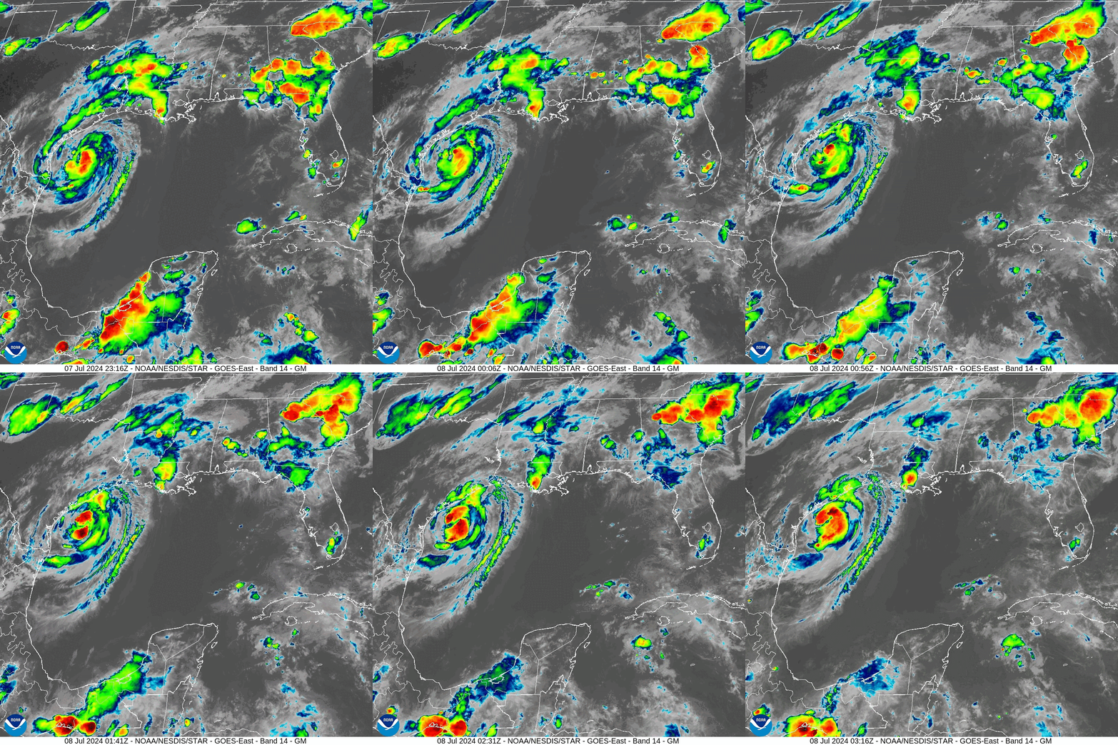
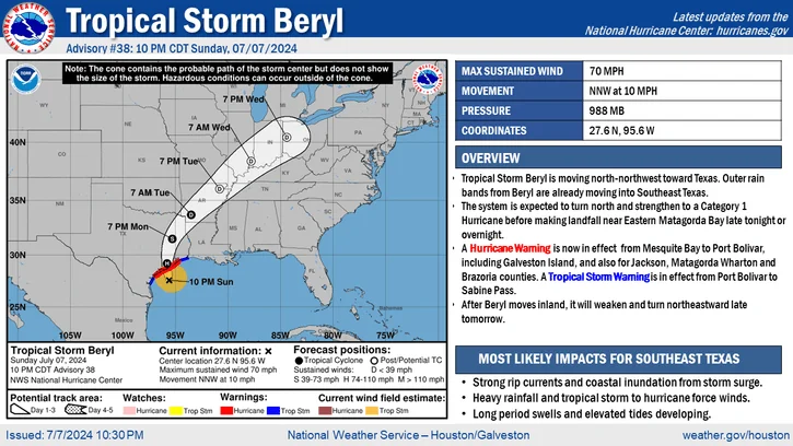
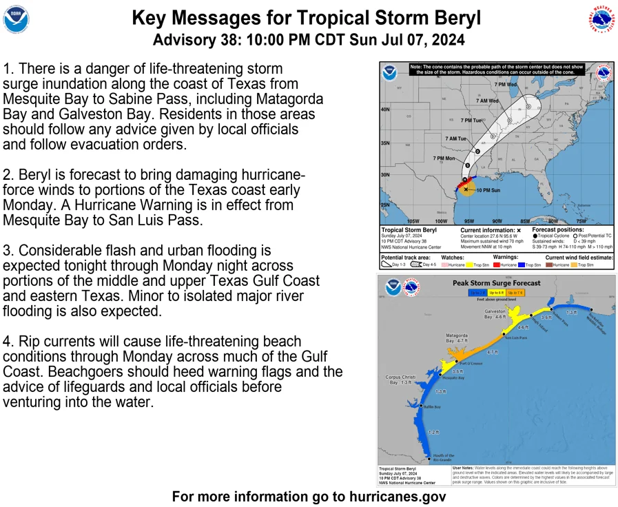
Tropical Storm Beryl Local Statement Advisory Number 38
National Weather Service Houston/Galveston TX  AL022024
1019 PM CDT Sun Jul 7 2024

This product covers Southeast Texas

**BERYL FORECAST TO MAKE LANDFALL AS A HURRICANE NEAR MATAGORDA BAY LATE TONIGHT**


NEW INFORMATION
---------------

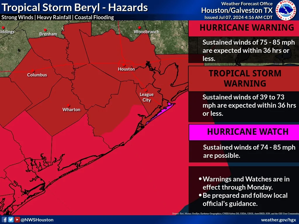
* CHANGES TO WATCHES AND WARNINGS:
    - The Tropical Storm Warning and Hurricane Watch have been
      upgraded to a Hurricane Warning for Galveston Island

* CURRENT WATCHES AND WARNINGS:
    - A Storm Surge Warning and Hurricane Warning are in effect for
      Brazoria Islands, Coastal Brazoria, Coastal Jackson, Coastal
      Matagorda, Galveston Island, and Matagorda Islands
    - A Hurricane Warning is in effect for Inland Brazoria, Inland
      Jackson, Inland Matagorda, and Wharton
    - A Storm Surge Warning and Tropical Storm Warning are in effect
      for Bolivar Peninsula, Chambers, Coastal Galveston, and Coastal
      Harris
    - A Tropical Storm Warning is in effect for Austin, Brazos,
      Burleson, Colorado, Fort Bend, Grimes, Houston, Inland
      Galveston, Inland Harris, Madison, Montgomery, Northern
      Liberty, Polk, San Jacinto, Southern Liberty, Trinity, Walker,
      Waller, and Washington

* STORM INFORMATION:
    - About 130 miles south-southwest of Galveston TX or about 70
      miles south-southeast of Matagorda TX
    - 27.6N 95.6W
    - Storm Intensity 70 mph
    - Movement North-northwest or 345 degrees at 10 mph

SITUATION OVERVIEW
------------------

Tropical Storm Beryl has very nearly regained hurricane strength
within hours of landfall on the Texas Gulf Coast near Matagorda Bay.
Recent motion has been northerly, or just slightly east of due north,
and that track will continue through Monday as it crosses Southeast
Texas. Though the storm will weaken as it moves inland, it will
continue to bring gusty winds, periods of heavy rain, and potential
for brief tornadoes, particularly to areas east of the storm`s center.
The current forecast track brings the center of the storm just west of
the Houston metro tomorrow.

POTENTIAL IMPACTS
-----------------

* WIND:
Protect against life-threatening wind having possible extensive
impacts across the Matagorda Bay shoreline. Potential impacts in
this area include:
    - Considerable roof damage to sturdy buildings, with some having
      window, door, and garage door failures leading to structural
      damage. Mobile homes severely damaged, with some destroyed.
      Damage accentuated by airborne projectiles. Locations may be
      uninhabitable for weeks.
    - Many large trees snapped or uprooted along with fences and
      roadway signs blown over.
    - Some roads impassable from large debris, and more within urban
      or heavily wooded places. Several bridges, causeways, and
      access routes impassable.
    - Large areas with power and communications outages.

Also, protect against dangerous wind having possible limited to
significant impacts across the rest of Southeast Texas.

* SURGE:
Protect against life-threatening surge having possible extensive
impacts across the Matagorda Bay shoreline. Potential impacts in
this area include:
    - Large areas of deep inundation with storm surge flooding
      accentuated by battering waves. Structural damage to buildings,
      with several washing away. Damage compounded by floating
      debris. Locations may be uninhabitable for an extended period.
    - Large sections of near-shore escape routes and secondary roads
      washed out or severely flooded. Flood control systems and
      barriers may become stressed.
    - Severe beach erosion with significant dune loss.
    - Major damage to marinas, docks, boardwalks, and piers. Many
      small craft broken away from moorings, especially in
      unprotected anchorages with some lifted onshore and stranded.

* FLOODING RAIN:
Protect against life-threatening rainfall flooding having possible
extensive impacts across Southeast Texas. Potential impacts include:
    - Major rainfall flooding may prompt many evacuations and rescues.
    - Rivers and tributaries may rapidly overflow their banks in
      multiple places. Small streams, creeks, canals, and ditches may
      become dangerous rivers. Flood control systems and barriers may
      become stressed.
    - Flood waters can enter many structures within multiple
      communities, some structures becoming uninhabitable or washed
      away. Many places where flood waters may cover escape routes.
      Streets and parking lots become rivers of moving water with
      underpasses submerged. Driving conditions become dangerous.
      Many road and bridge closures with some weakened or washed out.

* TORNADOES:
Protect against a dangerous tornado event having possible significant
impacts across much of Southeast Texas. Potential impacts
include:
    - The occurrence of scattered tornadoes can hinder the execution
      of emergency plans during tropical events.
    - Several places may experience tornado damage with a few spots
      of considerable damage, power loss, and communications failures.
    - Locations could realize roofs torn off frame houses, mobile
      homes demolished, boxcars overturned, large trees snapped or
      uprooted, vehicles tumbled, and small boats tossed about.
      Dangerous projectiles can add to the toll.

Protect against a tornado event having possible limited impacts
across far inland Southeast Texas.

PRECAUTIONARY/PREPAREDNESS ACTIONS
----------------------------------

* EVACUATIONS:
Follow the advice of local officials.


* OTHER PREPAREDNESS INFORMATION:
It is important to remain calm, informed, and focused during an
emergency. Be patient and helpful with those you encounter.

If you are a visitor, be sure to know the name of the city or town in
which you are staying and the name of the county or parish in which
it resides. Listen for these locations in local news updates. Pay
attention for instructions from local authorities.

Storm surge is the leading killer associated with tropical storms and
hurricanes! Make sure you are in a safe area away from the surge
zone. Even if you are not in a surge-prone area, you could find
yourself cutoff by flood waters during and after the storm. Heed
evacuation orders issued by the local authorities.

Closely monitor weather.gov, NOAA Weather radio or local news outlets
for official storm information. Be ready to adapt to possible changes
to the forecast. Ensure you have multiple ways to receive weather
warnings.


* ADDITIONAL SOURCES OF INFORMATION:
- For information on appropriate preparations see ready.gov
- For information on creating an emergency plan see getagameplan.org
- For additional disaster preparedness information see redcross.org
Updated July 7, 2024 6:15 PM
Tropical Storm Beryl: Latest Updates and Impact on Huntsville, TX
LOCATION...26.8N 95.5W
ABOUT 130 MI...205 KM SSE OF MATAGORDA TEXAS
ABOUT 135 MI...220 KM ESE OF CORPUS CHRISTI TEXAS
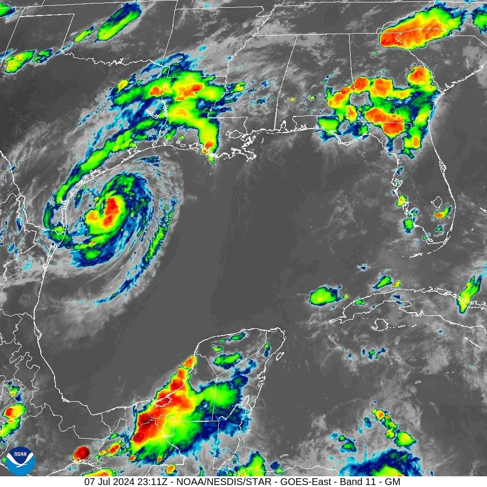
HUNTSVILLE, TX – Tropical Storm Beryl continues to strengthen as it approaches the Texas coast, posing significant threats to Southeast Texas, including Huntsville. Mike Brennan from the National Hurricane Center provided the latest details in a 4 p.m. update today.
According to Brennan, Beryl has shown signs of better organization, with peak winds reaching 65 miles per hour and the central pressure dropping to 988 millibars. The storm is moving north-northwest at 12 miles per hour, expected to make landfall overnight near the middle Texas coast.
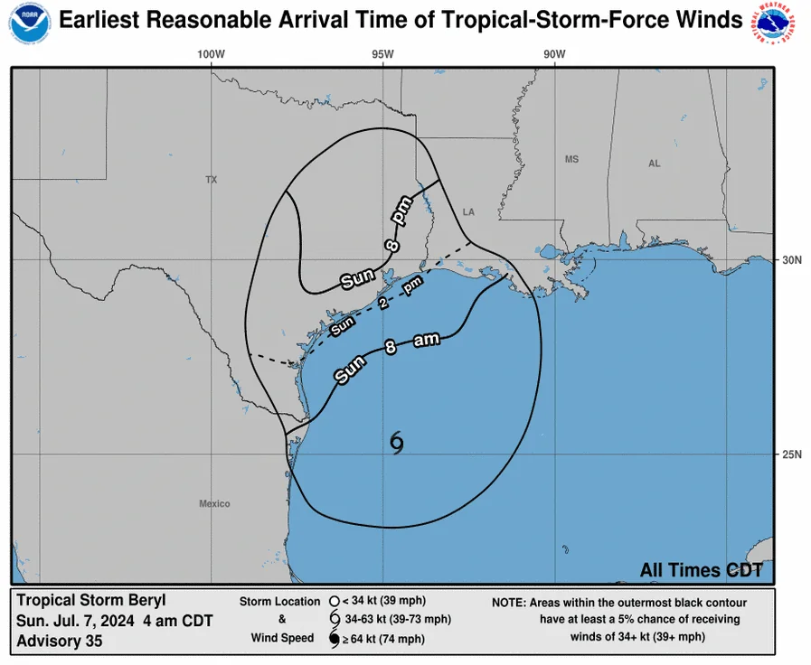
Impact on Huntsville The Huntsville area is under a tropical storm warning due to anticipated severe weather conditions. Forecasts indicate that the highest winds in Huntsville will occur around 1 p.m. on Monday, with gusts reaching up to 60 miles per hour and sustained winds near tropical storm strength.
Residents should prepare for hazardous conditions, including potential flash flooding and power outages. The storm's trajectory suggests significant rainfall, with estimates of 5 to 10 inches across the region. Local authorities have emphasized the importance of staying indoors and having multiple ways to receive emergency information.
Key Hazards
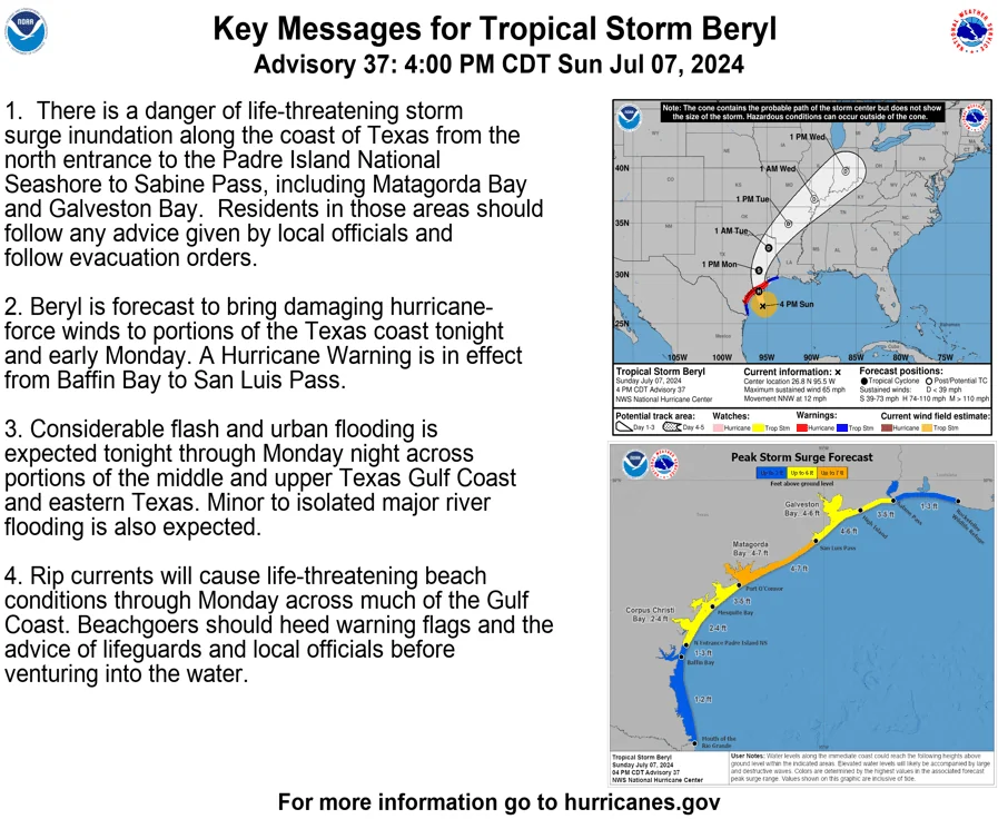
- Storm Surge: Coastal areas from Port O'Connor to San Luis Pass, including Galveston Bay, could see storm surge inundation of 4 to 7 feet.
- Rainfall: Widespread heavy rainfall could lead to flash flooding, with some areas potentially receiving up to 15 inches.
- Wind: Tropical storm conditions with gusts up to 60 miles per hour will likely impact Huntsville by early Monday afternoon.
From the National Hurricane Center Sunday 4 PM Update
BULLETIN
Tropical Storm Beryl Advisory Number  37
NWS National Hurricane Center Miami FL       AL022024
400 PM CDT Sun Jul 07 2024

...BERYL FORECAST TO BRING DANGEROUS STORM SURGE, FLASH FLOODING
AND STRONG WINDS TO TEXAS OVERNIGHT...


SUMMARY OF 400 PM CDT...2100 UTC...INFORMATION
----------------------------------------------
LOCATION...26.8N 95.5W
ABOUT 130 MI...205 KM SSE OF MATAGORDA TEXAS
ABOUT 135 MI...220 KM ESE OF CORPUS CHRISTI TEXAS
MAXIMUM SUSTAINED WINDS...65 MPH...100 KM/H
PRESENT MOVEMENT...NNW OR 335 DEGREES AT 12 MPH...19 KM/H
MINIMUM CENTRAL PRESSURE...988 MB...29.18 INCHES


WATCHES AND WARNINGS
--------------------
CHANGES WITH THIS ADVISORY:

The government of Mexico has discontinued the Tropical Storm
Warning for northeastern coast of mainland Mexico from Barra el
Mezquital to the mouth of the Rio Grande River.

The Storm Surge Watch from North of Baffin Bay, Texas to North
Entrance of the Padre Island National Seashore has been
discontinued.

SUMMARY OF WATCHES AND WARNINGS IN EFFECT:

A Storm Surge Warning is in effect for...
* North Entrance of the Padre Island National Seashore to Sabine
Pass, including Corpus Christi Bay, Matagorda Bay, and Galveston
Bay

A Hurricane Warning is in effect for...
* The Texas coast from Baffin Bay northward to San Luis Pass

A Hurricane Watch is in effect for...
* The Texas coast north of San Luis Pass to Galveston Island

A Tropical Storm Warning is in effect for...
* The Texas coast south of Baffin Bay to the mouth of the Rio
Grande
* The Texas coast north of San Luis Pass to Sabine Pass

A Hurricane Warning means that hurricane conditions are expected
somewhere within the warning area.

A Hurricane Watch means that hurricane conditions are possible
within the watch area.

A Tropical Storm Warning means that tropical storm conditions are
expected within the warning area.

A Storm Surge Warning means there is a danger of life-threatening
inundation, from rising water moving inland from the coastline,
during the next 36 hours in the indicated locations. For a
depiction of areas at risk, please see the National Weather
Service Storm Surge Watch/Warning Graphic, available at
hurricanes.gov.  This is a life-threatening situation.  Persons
located within these areas should take all necessary actions to
protect life and property from rising water and the potential for
other dangerous conditions.  Promptly follow evacuation and other
instructions from local officials.

For storm information specific to your area, including possible
inland watches and warnings, please monitor products issued by your
local National Weather Service forecast office.


DISCUSSION AND OUTLOOK
----------------------
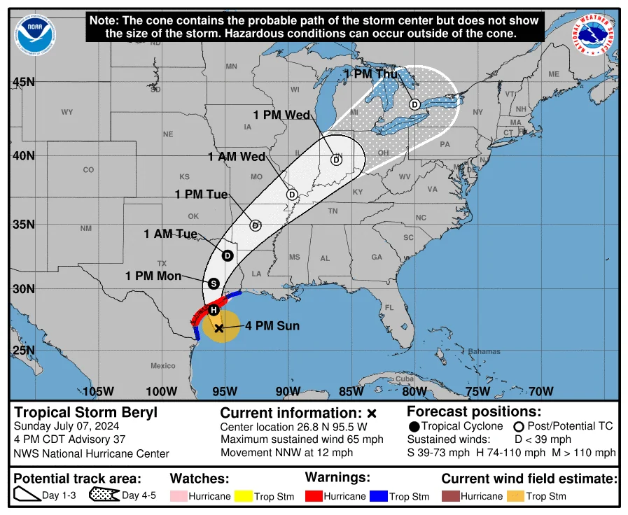
At 400 PM CDT (2100 UTC), the center of Tropical Storm Beryl was
located near latitude 26.8 North, longitude 95.5 West. Beryl is
moving toward the north-northwest near 12 mph (19 km/h).  This
general motion is expected to continue through tonight, with a turn
toward the north forecast on Monday. On the forecast track, the
center of Beryl is expected to make landfall on the middle Texas
coast early Monday. Beryl is forecast to turn northeastward and move
farther inland over eastern Texas and Arkansas late Monday and
Tuesday.

Maximum sustained winds remain near 65 mph (100 km/h) with higher
gusts.  Strengthening is expected, and Beryl is forecast to
become a hurricane again tonight. Additional strengthening is
expected before Beryl reaches the Texas coast early Monday.

Tropical-storm-force winds extend outward up to 115 miles (185 km)
from the center.

The estimated minimum central pressure is 988 mb (29.18 inches)
based on Air Force Reserve dropsonde data.


HAZARDS AFFECTING LAND
----------------------
Key messages for Beryl can be found in the Tropical Cyclone
Discussion under AWIPS header MIATCDAT2, WMO header WTNT42 KNHC,
and on the NHC website at hurricanes.gov/text/MIATCDAT2.shtml.

WIND: Hurricane conditions are expected in the hurricane warning
area by early Monday.  Winds are first expected to reach tropical
storm strength by late today, making outdoor preparations difficult
or dangerous.

Hurricane conditions are possible in the hurricane watch areas by
early Monday, with tropical storm conditions beginning by tonight.

Tropical storm conditions are expected in the tropical storm
warning areas in south Texas starting within the next few hours.

Tropical storm conditions are expected in the tropical storm
warning area along the upper Texas coast early Monday.

STORM SURGE: The combination of storm surge and tide will cause
normally dry areas near the coast to be flooded by rising waters
moving inland from the shoreline.  The water could reach the
following heights above ground somewhere in the indicated areas if
the peak surge occurs at the time of high tide...

Port O'Connor, TX to San Luis Pass, TX...4-7 ft
Matagorda Bay...4-7 ft
San Luis Pass, TX to High Island, TX...4-6 ft
Galveston Bay...4-6 ft
Mesquite Bay, TX to Port O'Connor, TX...3-5 ft
High Island, TX to Sabine Pass, TX...3-5 ft

The deepest water will occur along the immediate coast near and to
the right of the center, where the surge will be accompanied by
large and destructive waves. Surge-related flooding depends on the
relative timing of the surge and the tidal cycle, and can vary
greatly over short distances.  For information specific to your
area, please see products issued by your local National Weather
Service forecast office.

For a complete depiction of areas at risk of storm surge inundation,
please see the National Weather Service Peak Storm Surge Graphic,
available at hurricanes.gov/graphics_at2.shtml?peakSurge.

RAINFALL:  Heavy rainfall of 5 to 10 inches with localized amounts
of 15 inches is expected across portions of the middle and upper
Texas Gulf Coast and eastern Texas through Monday night.
Considerable flash and urban flooding as well as minor to isolated
major river flooding is expected.

For a complete depiction of forecast rainfall and flash flooding
associated with Tropical Storm Beryl, please see the National
Weather Service Storm Total Rainfall Graphic, available at
hurricanes.gov/graphics_at2.shtml?rainqpf and the Flash Flood Risk
graphic at hurricanes.gov/graphics_at2.shtml?ero

TORNADOES: A few tornadoes could occur along the middle and upper
Texas Coast through tonight, and across eastern Texas into Louisiana
and Arkansas on Monday.

SURF:  Swells generated by Beryl are expected to affect eastern
Mexico and much of the Gulf Coast of the U.S. during the next day
or two.  These swells are expected to cause life-threatening
surf and rip current conditions. Please consult products from your
local weather office.
Updated July 7, 2024 12:51 PM
NHC Update: Intensifying Tropical Storm Beryl to Impact Texas Coast
The National Hurricane Center has issued an urgent update on intensifying Tropical Storm Beryl, currently centered approximately 200 miles southeast of Corpus Christi, Texas, and moving northwestward at around 10 mph. According to NHC Director Mike Brennan, Beryl is expected to regain hurricane strength before making landfall along the Texas coast.
"Air Force Reserve Hurricane Hunter aircraft have detected maximum sustained winds of about 65 mph, with Beryl becoming better organized on radar," Brennan reported. "We anticipate the storm will reach hurricane strength before making landfall overnight tonight or early Monday morning."
Beryl's impending landfall will bring multiple hazards to the Texas coast. "Conditions are going to deteriorate quickly along the coast as we move through the afternoon and evening. Outer rain bands are already affecting southeastern Texas," Brennan stated.
Impact on Huntsville, TX
Huntsville, TX, is expected to experience significant effects from Beryl, including heavy rainfall and potential flash flooding. "We're looking at widespread heavy rainfall across eastern Texas, with five to ten inches expected and some areas possibly seeing up to 15 inches," Brennan noted. Flash flood watches are in effect for regions including Huntsville, Bryan, and College Station.
Storm Surge and Wind Warnings
A storm surge warning is in effect for much of the Texas coast, with the most severe inundation expected from Mesquite Bay eastward to San Luis Pass. "We could see up to six feet of inundation in places like Port O'Connor and Matagorda Bay," said Brennan. "Life-threatening storm surge is anticipated in these regions."
Hurricane warnings have been issued from Baffin Bay to San Luis Pass, including Corpus Christi and Victoria. "Damaging hurricane-force winds are expected along portions of the Texas coast tonight and early Monday, particularly from Mesquite Bay up to San Luis Pass," Brennan cautioned.
Flood and Tornado Threats
The storm's heavy rainfall poses a significant flash flooding threat, particularly along and east of the I-45 corridor, affecting areas such as Tyler, Palestine, and into the Ark-La-Tex region. "The greatest risk for flash flooding is along the coast where Beryl is expected to make landfall, with flash flood risks extending into southeastern Texas and Louisiana," Brennan explained.
In addition, there is a heightened tornado threat in southeast Texas, including Beaumont and Houston, as Beryl's outer rain bands move ashore.
Preparation and Safety Measures
Brennan urged residents to complete storm preparations and heed evacuation orders. "Preparation should be rushed to completion before tropical storm-force winds begin later today. Ensure you have multiple ways to receive emergency information, especially through the overnight hours," he advised.
The NHC will continue to monitor Beryl closely and provide updates as the situation develops. For now, residents are encouraged to stay informed and take all necessary precautions to ensure their safety.
Updated July 7, 2024 10:04 AM
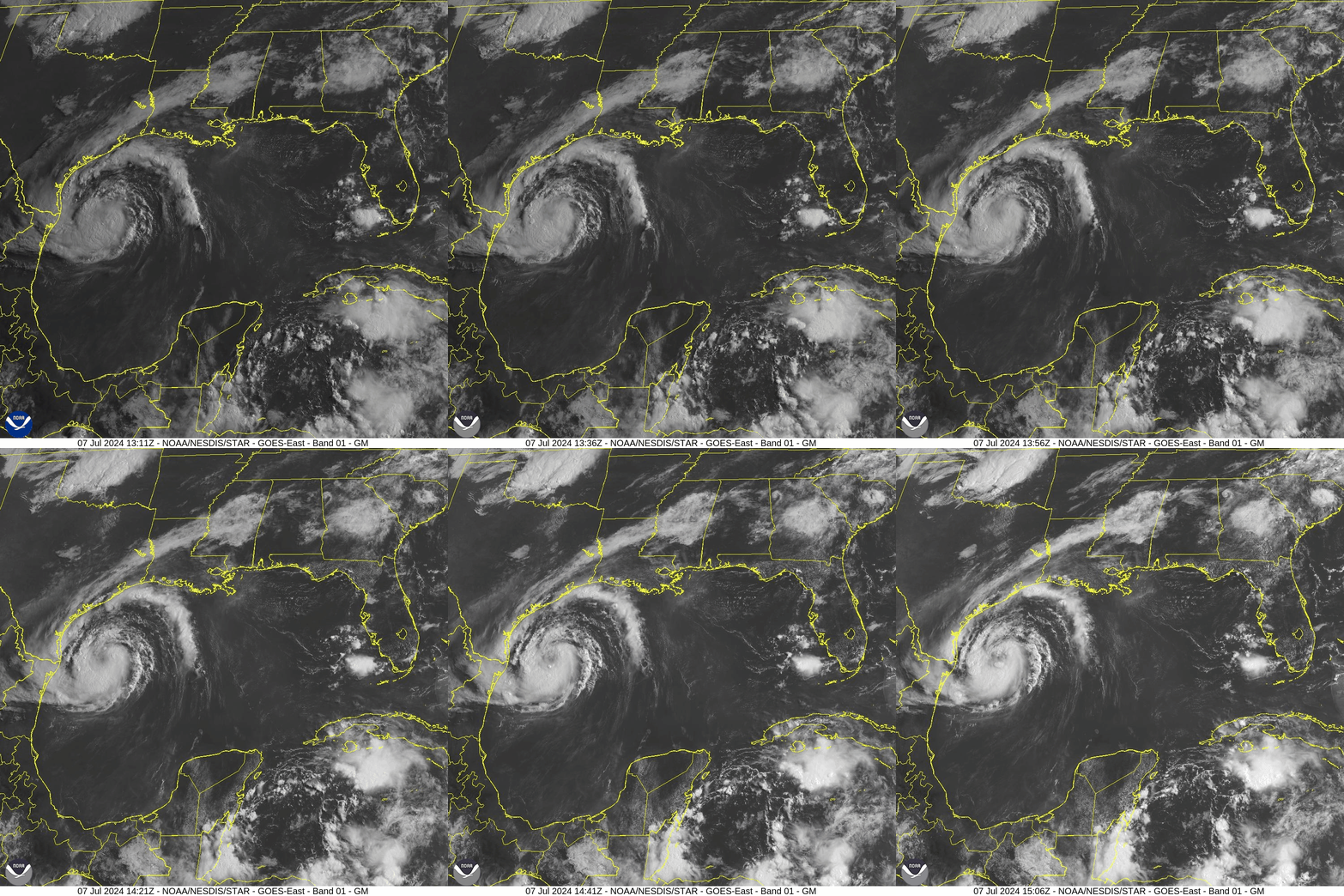
- Location: 195 miles southeast of Corpus Christi, Texas, and Matagorda, Texas
- Movement: Northwest at 10 mph
- Maximum Sustained Winds: 65 mph
- Minimum Central Pressure: 992 mb
- Warnings Issued:
- Storm Surge Warning from the North Entrance of the Padre Island National Seashore to Sabine Pass, including Corpus Christi Bay, Matagorda Bay, and Galveston Bay
- Hurricane Warning from Baffin Bay to San Luis Pass
- Hurricane Watch north of San Luis Pass to Galveston Island
- Tropical Storm Warning south of Baffin Bay to the mouth of the Rio Grande and north of San Luis Pass to Sabine Pass
- Tropical Storm Warning for the northeastern coast of mainland Mexico from Barra el Mezquital to the mouth of the Rio Grande River
- Changes with the New Advisory:
- Storm Surge Warning issued for High Island to Sabine Pass
- Storm Surge Watch discontinued from the mouth of the Rio Grande to Baffin Bay, Texas
- Tropical Storm Watch upgraded to Tropical Storm Warning east of High Island to Sabine Pass
- Hurricane Watch discontinued south of Baffin Bay to the mouth of the Rio Grande
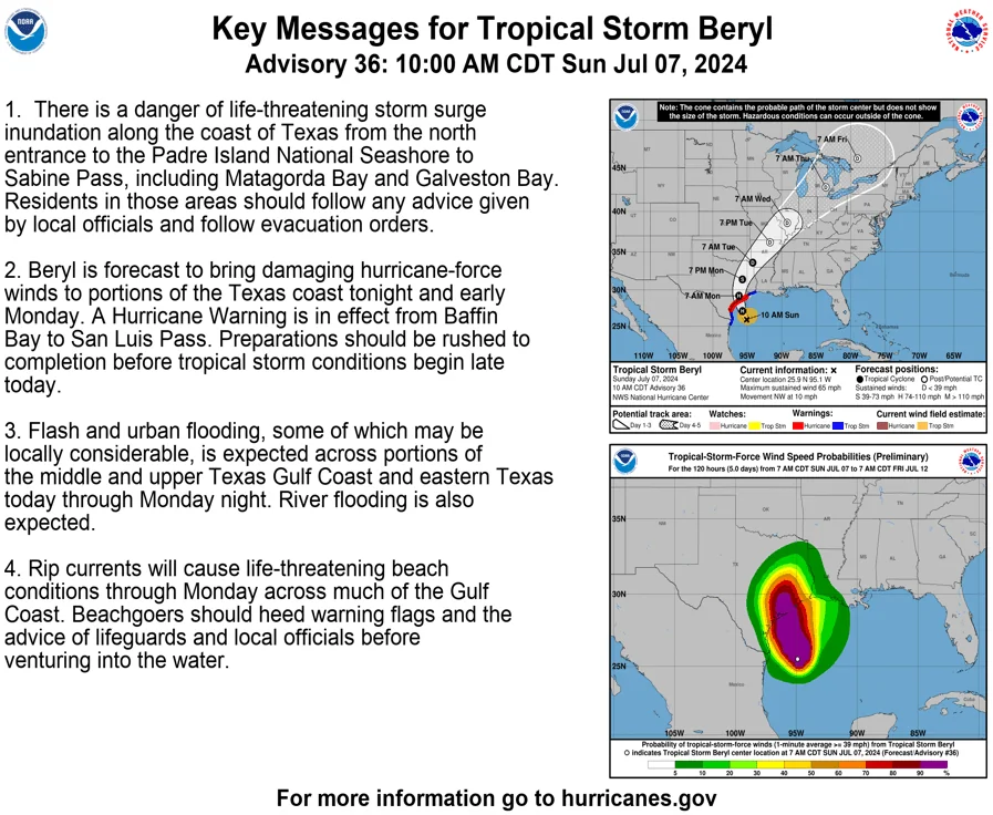
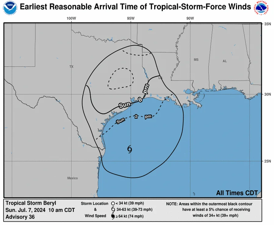
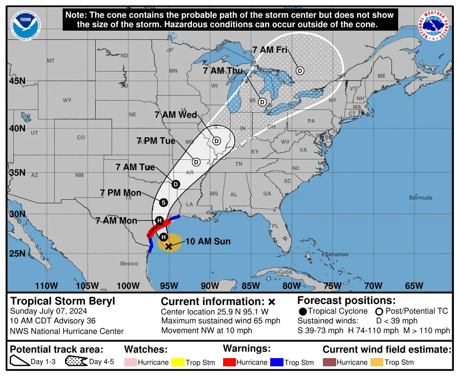
Flood Watch for Huntsville, TX (Walker County) from Late Tonight Through Tuesday Morning
The National Weather Service has issued a Flood Watch for Huntsville, TX, starting late tonight and lasting through Tuesday morning due to heavy rainfall from Tropical Storm Beryl.
Key Points:
- Expected Rainfall: 5 to 10 inches, with locally higher amounts possible.
- Potential Impacts: Flooding of rivers, creeks, streams, and other low-lying areas. Urban and poor drainage areas may also experience flooding.
- Timing: Late tonight through Tuesday morning.
Residents should monitor forecasts and be prepared for possible flood warnings. Take action if flooding develops in your area.
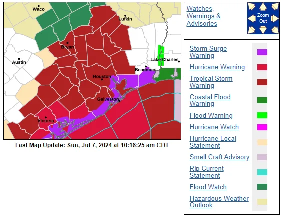
🌀 Tropical Storm Warning in Effect for Huntsville 🌀
A Tropical Storm Warning means tropical storm-force winds are expected within the next 36 hours.
Key Details:
- Locations Affected: Huntsville, New Waverly, Riverside
- Wind: Peak winds of 35-45 mph with gusts up to 75 mph expected from early Monday morning until Monday afternoon
- Potential Impacts: Significant wind damage to roofs, siding, porches, and mobile homes. Uprooted trees, downed power lines, and impassable roads due to debris.
Updated July 7, 2024 7:53 AM
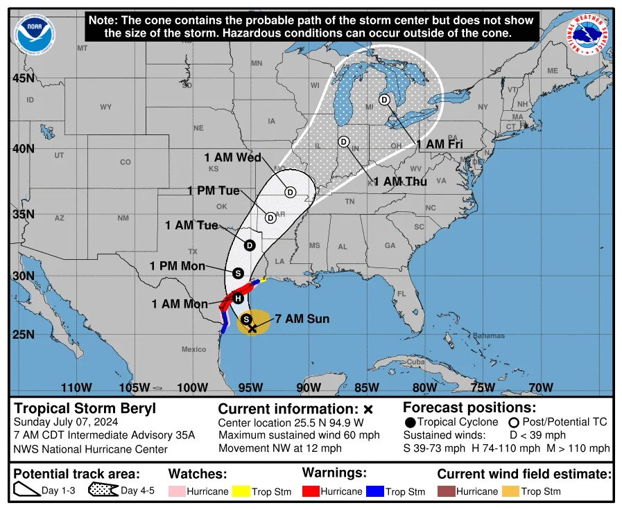
Update on Tropical Storm Beryl
- Time: 7:00 AM CDT, Sunday, July 7, 2024
- Location: 25.5N 94.9W, about 225 miles SSE of Matagorda, Texas, and 220 miles SE of Corpus Christi, Texas.
- Maximum Sustained Winds: 60 mph
- Movement: NW at 12 mph
- Minimum Central Pressure: 992 mb
Current Status
- Air Force Reserve Hurricane Hunter: Currently investigating the storm.
- Strengthening Expected: Beryl is forecast to become a hurricane before making landfall.
Watches and Warnings
- Hurricane Warning: Texas coast from Baffin Bay to San Luis Pass.
- Hurricane Watch: Texas coast south of Baffin Bay to the Rio Grande River and north of San Luis Pass to Galveston Island.
- Tropical Storm Warning: Texas coast south of Baffin Bay to the Rio Grande River and north of San Luis Pass to High Island, and the northeastern coast of mainland Mexico from Barra el Mezquital to the Rio Grande River.
- Storm Surge Warning: North Entrance of the Padre Island National Seashore to High Island, including Corpus Christi Bay, Matagorda Bay, and Galveston Bay.
- Storm Surge Watch: Texas coast from the Rio Grande River to the North Entrance of the Padre Island National Seashore and High Island to Sabine Pass.
- Tropical Storm Watch: Texas coast east of High Island to Sabine Pass.
Expected Impacts in Huntsville, TX
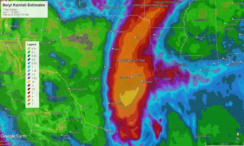
- Rainfall: Heavy rainfall of 5 to 10 inches with localized amounts up to 15 inches is expected. This could lead to flash and urban flooding, particularly from Sunday evening through Monday night.
- Winds: Huntsville may experience tropical storm-force winds, which could lead to downed trees and power outages. Secure any loose outdoor items.
- Flooding: There is a potential for minor to moderate river flooding. Residents in low-lying areas should be prepared for possible evacuation.
- Tornadoes: There is a risk of isolated tornadoes, especially in the evening and overnight hours as Beryl moves inland.
- Surf and Rip Currents: Swells generated by Beryl will cause dangerous surf and rip current conditions along the Texas Gulf Coast. Beachgoers should exercise caution and follow local advisories.
Updated 7/6/2024 5:23 PM
National Hurricane Center Issues Warnings as Tropical Storm Beryl Approaches Texas Coast
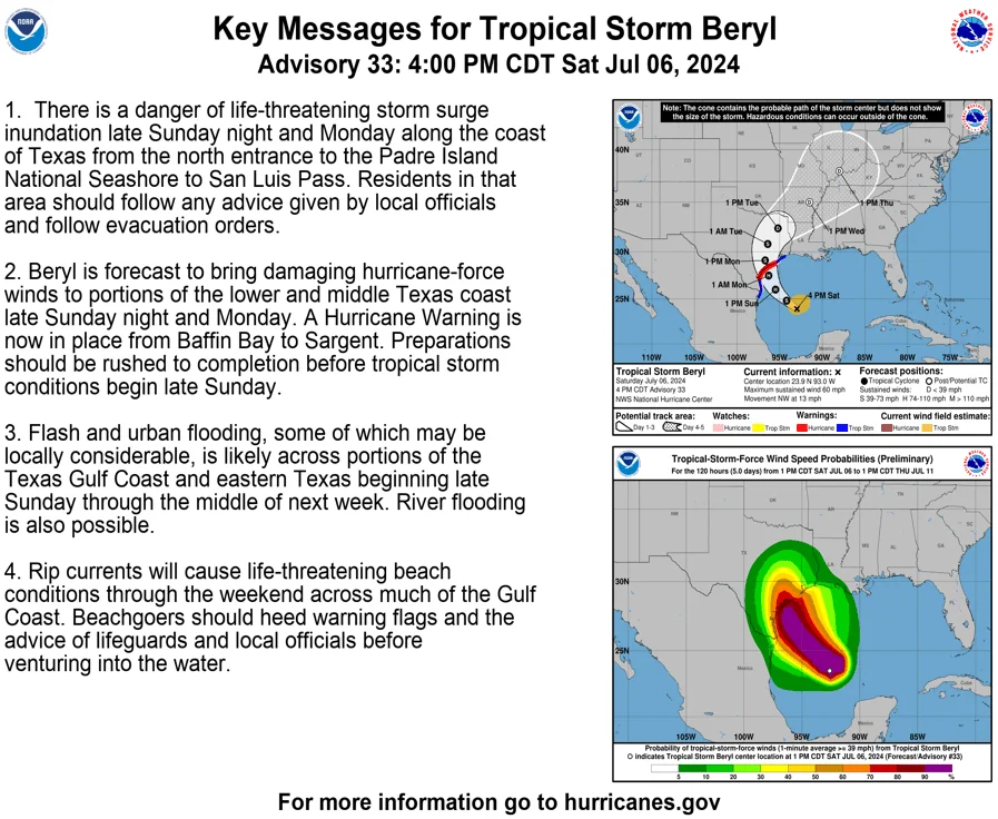
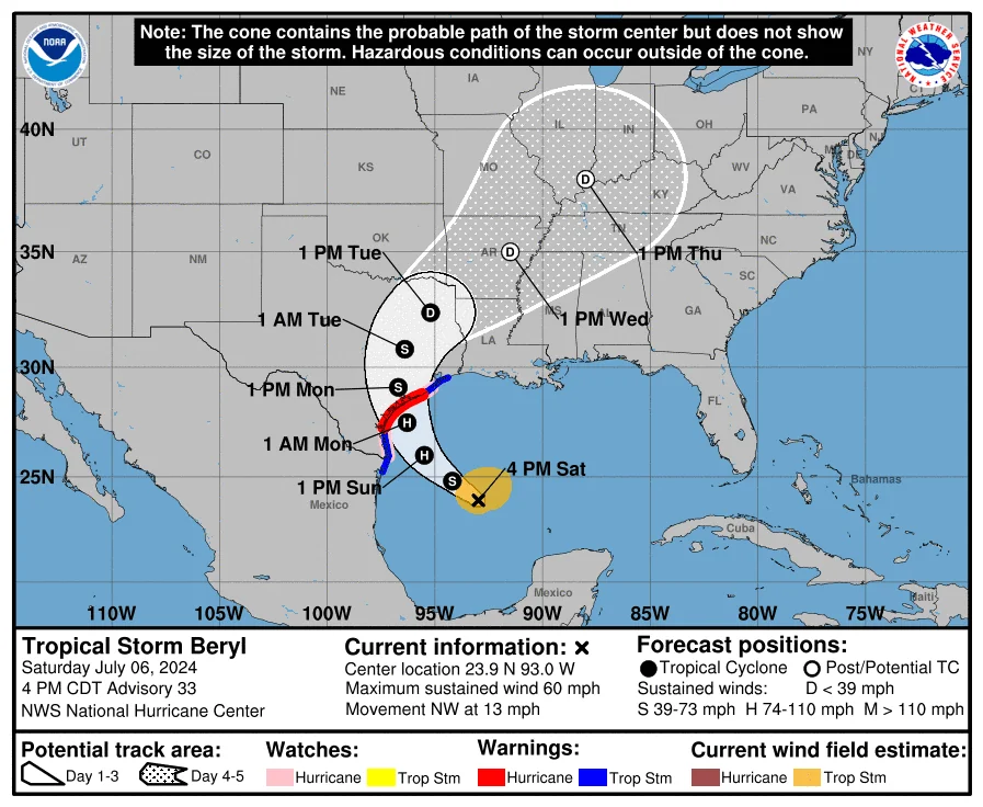
The National Hurricane Center (NHC) has issued storm surge and hurricane warnings for portions of the Texas coast as Tropical Storm Beryl continues its approach. The latest advisory, delivered by NHC's Mike Brennan, emphasizes the urgent need for residents in the affected areas to prepare for severe weather conditions.
As of 4 p.m. Central Time, Beryl remains a tropical storm with sustained winds of 60 mph, moving northwest at 13 mph. It is currently situated about 385 miles southeast of Corpus Christi, Texas. Beryl is expected to intensify into a hurricane before making landfall overnight Sunday into early Monday.
Storm Surge Warnings
A storm surge warning is in effect from the north entrance of the South Padre Island National Seashore to San Luis Pass. This includes Corpus Christi Bay, Mesquite Bay, and Matagorda Bay. Life-threatening inundation of 4 to 6 feet above ground level is anticipated in areas between Mesquite Bay and Sargent, with 3 to 5 feet expected from Sargent to San Luis Pass and south of Mesquite Bay to the North Entrance of the South Padre Island National Seashore. Additionally, a storm surge watch is in effect for Galveston Bay, where 2 to 4 feet of inundation is possible.
Hurricane Warnings
A hurricane warning is now issued from Baffin Bay to Sargent, with a tropical storm warning extending north of Sargent to High Island and south of Baffin Bay to the mouth of the Rio Grande, including northeastern Mexico. Beryl is forecasted to reach hurricane strength by Sunday and continue to strengthen as it approaches the Texas coast. Residents in the hurricane warning area should prepare for hurricane-force winds, secure their homes, and complete necessary preparations by early Sunday afternoon.
Rainfall and Flooding
Beryl is expected to bring significant rainfall to the Texas Gulf Coast and eastern Texas, with totals ranging from 5 to 10 inches and isolated areas receiving up to 15 inches. The heavy rainfall poses a substantial flooding risk, particularly in flood-prone areas. Flash flood warnings and watches may be issued as the storm progresses.
Tornado Risk
There is also a risk of tornadoes late Sunday into Sunday night along the Texas Gulf Coast, from Houston to Corpus Christi. Tornadoes can develop quickly within tropical storm and hurricane rainbands, adding another layer of danger to the approaching storm.
Residents in the affected areas are urged to heed evacuation orders and take all necessary precautions to ensure their safety. The NHC will continue to monitor Beryl closely and provide updates as the situation develops.
Updated 7/6/2024 8:42 AM
Beryl Expected to Regain Strength Before Landfall
Beryl, currently a tropical storm, has entered the Gulf of Mexico and was approximately 545 miles from Corpus Christi, Texas, as of Saturday morning. After bringing strong winds, torrential rainfall, and dangerous storm surge to Mexico’s Yucatan Peninsula and several Caribbean islands, Beryl is forecasted to strengthen again on Sunday before its anticipated final landfall in South Texas.
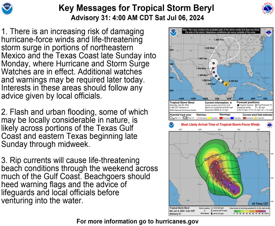
Hurricane and Storm Surge Watches Issued
Hurricane and storm surge watches were extended eastward along the Texas coast on Friday night. The Texas coast is now under a hurricane watch from the mouth of the Rio Grande north to San Luis Pass. A storm surge watch is also in effect from the Rio Grande north to High Island, including coastal Harris County. Additionally, a hurricane watch has been issued for the northeastern coast of Mexico, from Barra el Mezquital to the mouth of the Rio Grande.
Hurricane Beryl's anticipated landfall and strengthening pose several potential impacts for Huntsville, TX:
- Heavy Rainfall: Huntsville is expected to receive significant rainfall beginning late Sunday through midweek. Forecast models estimate between 5 to 7 inches of rain, which could lead to flash flooding and urban flooding in the area.
- Strong Winds: Although Huntsville is not on the immediate coast, the area could still experience strong winds associated with the outer bands of the storm as it moves inland.
- Flooding Risks: Given the heavy rainfall projections, there is a heightened risk of flooding, especially in low-lying and flood-prone areas.
- Storm Surge Impacts: While Huntsville itself is inland and not directly affected by storm surge, the overall weather system could cause rivers and streams to swell, leading to further flooding risks.
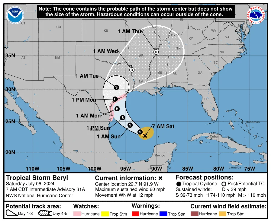
Tropical Storm Beryl Intermediate Advisory Number 31A
NWS National Hurricane Center Miami FL       AL022024
700 AM CDT Sat Jul 06 2024

...HURRICANE HUNTER AIRCRAFT INVESTIGATING BERYL...
...EXPECTED TO BE A HURRICANE NEAR LANDFALL IN TEXAS...


SUMMARY OF 700 AM CDT...1200 UTC...INFORMATION
----------------------------------------------
LOCATION...22.7N 91.9W
ABOUT 495 MI...795 KM SE OF CORPUS CHRISTI TEXAS
MAXIMUM SUSTAINED WINDS...60 MPH...95 KM/H
PRESENT MOVEMENT...WNW OR 300 DEGREES AT 12 MPH...19 KM/H
MINIMUM CENTRAL PRESSURE...999 MB...29.50 INCHES


WATCHES AND WARNINGS
--------------------
CHANGES WITH THIS ADVISORY:

None.

SUMMARY OF WATCHES AND WARNINGS IN EFFECT:

A Hurricane Watch is in effect for...
* The Texas coast from the mouth of the Rio Grande northward
to San Luis Pass
* The northeastern coast of mainland Mexico from Barra el
Mezquital to the mouth of the Rio Grande

A Storm Surge Watch is in effect for...
* The Texas coast from the mouth of the Rio Grande northward
to High Island

A Hurricane Watch means that hurricane conditions are possible
within the watch area.  A watch is typically issued 48 hours
before the anticipated first occurrence of tropical-storm-force
winds, conditions that make outside preparations difficult or
dangerous.

A Storm Surge Watch means there is a possibility of life-
threatening inundation, from rising water moving inland from the
coastline, in the indicated locations during the next 48 hours.
For a depiction of areas at risk, please see the National Weather
Service Storm Surge Watch/Warning Graphic, available at
hurricanes.gov.

Interests elsewhere in northeastern Mexico and the Texas coast
should closely monitor the progress of Beryl. Additional watches
and warnings will likely be issued for portions of this area later
today.

For storm information specific to your area in the United
States, including possible inland watches and warnings, please
monitor products issued by your local National Weather Service
forecast office. For storm information specific to your area
outside of the United States, please monitor products issued by
your national meteorological service.


DISCUSSION AND OUTLOOK
----------------------
At 700 AM CDT (1200 UTC), the center of Tropical Storm Beryl was
located near latitude 22.7 North, longitude 91.9 West. Beryl is
moving toward the west-northwest near 12 mph (19 km/h). A turn to
the northwest is expected later today and then north-northwestward
by Sunday night. On the forecast track, the center of Beryl is
expected to approach the Texas coast by late Sunday into Monday
morning.

Reports from NOAA and Air Force Reserve Hurricane Hunter aircraft
indicate that maximum sustained winds are near 60 mph (95 km/h)
with higher gusts. Little change in strength is expected today, but
strengthening is expected to begin by Sunday, and Beryl is forecast
to become a hurricane before it reaches the Texas coast.

Tropical-storm-force winds extend outward up to 115 miles (185 km)
from the center.

The minimum central pressure estimated from the Hurricane Hunter
aircraft data is 999 mb (29.50 inches).


HAZARDS AFFECTING LAND
----------------------
Key messages for Beryl can be found in the Tropical Cyclone
Discussion under AWIPS header MIATCDAT2, WMO header WTNT42 KNHC,
and on the NHC website at hurricanes.gov/text/MIATCDAT2.shtml.

WIND: Hurricane conditions are possible in the hurricane watch area
along the Gulf coast of northeastern Mexico and Texas by early
Monday, with tropical storm conditions beginning Sunday night.

STORM SURGE: The combination of storm surge and tide will cause
normally dry areas near the coast to be flooded by rising waters
moving inland from the shoreline.  The water could reach the
following heights above ground somewhere in the indicated areas if
the peak surge occurs at the time of high tide...

Baffin Bay, TX to San Luis Pass, TX...3-5 ft
Corpus Christi Bay...3-5 ft
Matagorda Bay...3-5 ft
Mouth of the Rio Grande, TX to Baffin Bay, TX...2-4 ft
San Luis Pass, TX to High Island, TX...2-4 ft
Galveston Bay...2-4 ft

The deepest water will occur along the immediate coast near and to
the right of the center, where the surge will be accompanied by
large and destructive waves. Surge-related flooding depends on the
relative timing of the surge and the tidal cycle, and can vary
greatly over short distances.  For information specific to your
area, please see products issued by your local National Weather
Service forecast office.

For a complete depiction of areas at risk of storm surge inundation,
please see the National Weather Service Peak Storm Surge Graphic,
available at hurricanes.gov/graphics_at2.shtml?peakSurge.

RAINFALL:  Heavy rainfall of 5 to 10 inches with localized amounts
of 15 inches is expected across portions of the Texas Gulf Coast and
eastern Texas beginning late Sunday through midweek.  This rainfall
is likely to produce areas of flash and urban flooding, some of
which may be locally considerable in nature.

For a complete depiction of forecast rainfall and flash flooding
associated with Tropical Storm Beryl, please see the National
Weather Service Storm Total Rainfall Graphic, available at
hurricanes.gov/graphics_at2.shtml?rainqpf and the Flash Flood Risk
graphic at hurricanes.gov/graphics_at2.shtml?ero

SURF:  Large swells generated by Beryl are currently impacting
portions of the coast of the Yucatan Peninsula. The swells are
expected to reach eastern Mexico and much of the Gulf Coast of the
U.S. shortly. These swells are expected to cause life-threatening
surf and rip current conditions. Please consult products from your
local weather office.
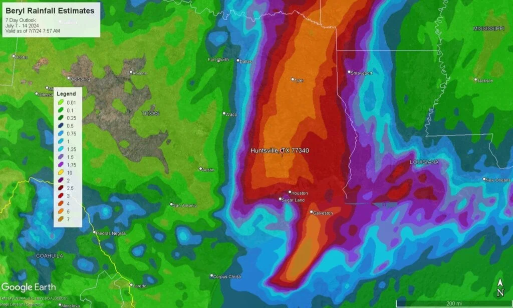
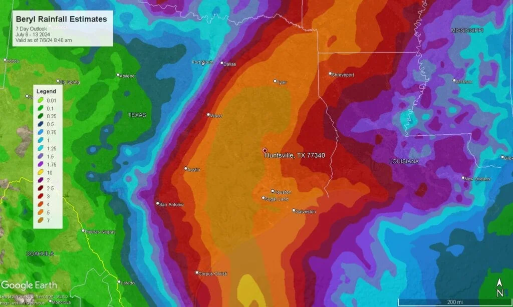
Rainfall estimates, as of 8:30 AM on July 6, 2024, still place Huntsville in the 5-7 inches category. However, if the storm tracks further northeast, the expected rainfall amounts will decrease. (See below for details.)
Updated July 5, 2024 6:21 PM
Current Status (as of update)
Tropical Storm Beryl is currently located north of the Yucatán Peninsula, with wind speeds around 65 mph. It has weakened from its previous hurricane status but is expected to re-strengthen once it enters the Gulf of Mexico.
Timeline and Forecast
- Friday, July 5, 2024: Beryl is expected to move into the Gulf of Mexico, where it may begin to strengthen again.
- Saturday, July 6, 2024: The storm will be over the Gulf, with conditions becoming more favorable for intensification.
- Sunday, July 7, 2024: Beryl is projected to approach the Texas Gulf Coast, potentially making landfall near Corpus Christi late Sunday night or early Monday morning as a Category 1 hurricane.
Expected Impacts
- Rainfall: Huntsville could receive up to 5 inches of rain from Sunday through the middle of next week. This heavy rainfall increases the risk of flash and urban flooding in the area.
- Wind: While the strongest winds will be near the coast, Huntsville may experience gusty conditions as the storm moves inland.
- Storm Surge and Rip Currents: Coastal areas will be at risk for life-threatening storm surges and dangerous rip currents.
Updated July 5, 2024 6:11 PM
Governor Abbott Provides Update On State Response To Hurricane Beryl
Announces Severe Weather Disaster Declaration For 40 Counties
As of this Update, Walker County Is Not Included
Governor Greg Abbott today provided an update on Texas' ongoing response efforts to Hurricane Beryl and announced a severe weather disaster declaration for 40 counties. The Texas Division of Emergency Management (TDEM) increased the readiness level of the State Emergency Operations Center as of 10 a.m. this morning and Texas Emergency Management Council agencies are working 24-hour operations, while also prepositioning state emergency response resources that were readied for deployment yesterday.
"As Hurricane Beryl approaches Texas, a severe weather disaster declaration has been issued for 40 counties to ensure at-risk communities have access to the resources and assistance needed to respond to this storm," said Governor Abbott. "I remain in daily contact with Acting Governor Patrick, the Texas Division of Emergency Management, and other state officials to ensure Texas swiftly deploys all resources needed to help Texans as heavy rainfall, flooding conditions, and strong tropical wind are expected to impact multiple regions of the state. I thank our state's emergency response personnel who are working around-the-clock to protect their fellow Texans. Holiday travelers and communities in at-risk areas are urged to heed the guidance of state and local officials to keep themselves and their families safe."
Counties in the disaster declaration issued by Lieutenant Governor Dan Patrick, as Acting Governor, include: Aransas, Atascosa, Bee, Bexar, Brooks, Calhoun, Cameron, DeWitt, Dimmit, Duval, Frio, Goliad, Gonzales, Hidalgo, Jackson, Jim Hogg, Jim Wells, Karnes, Kenedy, Kinney, Kleberg, LaSalle, Lavaca, Live Oak, Matagorda, Maverick, McMullen, Medina, Nueces, Refugio, San Patricio, Starr, Uvalde, Victoria, Webb, Wharton, Willacy, Wilson, Zapata, and Zavala. Additional counties may be added as conditions warrant.
According to the National Hurricane Center, Hurricane Beryl is expected to briefly weaken before intensifying as it moves northwestward through the Gulf of Mexico. As Beryl moves over water, the risk for rip currents along beaches across the Gulf Coast will increase. Beachgoers should heed warnings of lifeguards, local officials, posted signs, and flags before venturing into the water. Interests in Texas should closely monitor this system and prepare now for potential hurricane impacts, including heavy rainfall, flooding, and damaging winds, as the system moves inland across the state.
Texans are urged to stay informed, monitor local weather forecasts, follow directions from local officials, make an emergency plan, review hurricane evacuation routes, build a kit containing emergency supplies, and consider reviewing flood risk and insurance coverage. Additionally, visitors to Texas beaches should review beach safety tips and remain aware of the risks of rip currents during an approaching tropical system in the Gulf of Mexico.
Texans are encouraged to visit the TDEM Disaster Portal or Texas Hurricane Center webpages for storm information. Additional storm safety and preparedness information is available at TexasReady.gov and tdem.texas.gov/prepare.
Governor Abbott yesterday directed TDEM to increase the readiness level of the State Emergency Operations Center to Level II (Escalated Response Conditions) and to begin readying state emergency response resources for potential deployment ahead of Hurricane Beryl.
Lieutenant Governor Patrick is Acting Governor while Governor Abbott leads an economic development mission to Taiwan, South Korea, and Japan.
Read the disaster declaration.
Updated July 5, 2024 4:53 PM
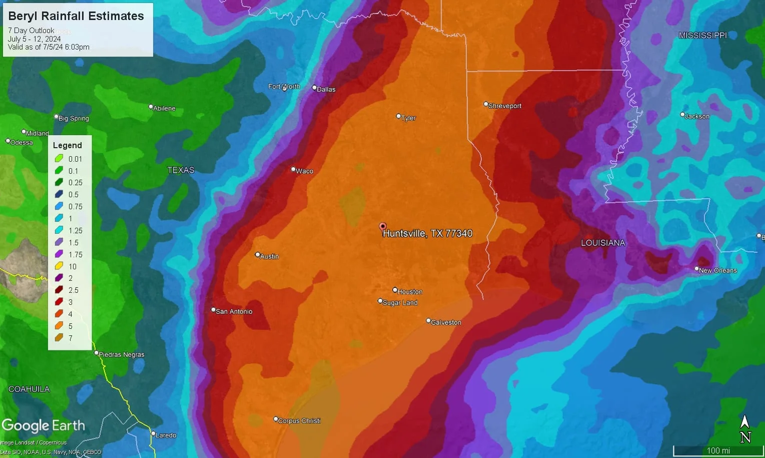
Forecast models indicate that Beryl will impact the Texas coast, passing just west of Huntsville. This trajectory places Huntsville directly in the path for potentially significant rainfall. According to the National Weather Service's current 7-day model, as of July 5, Huntsville could receive between 5 to 7 inches of rain.
Hurricane Preparedness Guide for Huntsville, TX
As Hurricane Beryl approaches, it's important to be thorough in your preparations. Below are detailed steps to enhance your readiness:
1. Stay Informed
- Monitor Updates:
- National Hurricane Center (NHC): Visit NHC's website for real-time updates and forecasts.
- Local News: Tune into local news stations like KHOU 11 or KBTX for regular updates.
- Weather Apps: Download weather apps such as The Weather Channel, AccuWeather, or WeatherBug for mobile alerts.
- Weather Alerts:
- NOAA Weather Radio: Purchase a NOAA Weather Radio for continuous updates. You can find these at most electronics stores or online.
- Wireless Emergency Alerts (WEA): Ensure your mobile phone is enabled to receive WEA. Most modern smartphones have this feature enabled by default.
- Emergency Management Services: Sign up for alerts from local emergency management services. For Walker County, follow their Facebook page and download the Walker County OEM app for updates.
2. Emergency Kit
- Water: Purchase bottled water from local grocery stores or big-box retailers like Walmart or H-E-B. Aim for at least one gallon per person per day for three days.
- Food: Stock up on non-perishable items such as canned goods, dry cereal, peanut butter, and granola bars. Ensure you have a manual can opener.
- Medications: Refill any prescriptions at your local pharmacy. Keep a seven-day supply of medications in a waterproof container.
- First Aid Kit: Assemble a kit with bandages, antiseptic wipes, tweezers, scissors, and pain relievers. Pre-made kits are available at pharmacies and online.
- Important Documents: Store copies of insurance policies, identification, and bank records in a waterproof container or a secure digital location.
- Flashlights and Batteries: Purchase from hardware stores or online. Consider rechargeable batteries and a solar charger.
- Tools: Have a basic toolkit ready, including a wrench, pliers, and duct tape.
- Sanitation Items: Include moist towelettes, garbage bags, and plastic ties for personal sanitation.
3. Home Preparation
- Secure Property: Store outdoor items like furniture and decorations inside your garage or house. Tie down any items that cannot be brought inside.
- Shutter Windows: Install storm shutters or use plywood to cover windows. Supplies can be found at hardware stores like Home Depot or Lowe's.
- Trim Trees: Hire a local tree service to remove any weak branches or trees that could fall during the storm.
- Check Drains and Gutters: Clean out debris to ensure proper drainage and prevent flooding. Use a ladder safely or hire a professional if necessary.
4. Evacuation Plan
- Know Your Route: Familiarize yourself with the Texas Department of Transportation's (TxDOT) evacuation routes.
- Emergency Contacts: Create a list of contacts, including family members, friends, and local emergency services. Keep this list in your emergency kit.
- Pet Plan: Ensure you have food, water, and a carrier for each pet. Check for pet-friendly shelters or hotels in advance.
5. During the Storm
- Stay Indoors: Stay away from windows and doors. Use a safe room or interior room on the lowest floor of your home.
- Listen to Authorities: Follow instructions from local officials, including evacuation orders and safety updates.
6. After the Storm
- Wait for the All-Clear: Only return home when authorities confirm it is safe.
- Inspect Your Home: Check for structural damage, gas leaks, and electrical issues. Report any hazards to local authorities.
- Avoid Flood Waters: Do not walk or drive through flooded areas as they may be contaminated or electrically charged.
Additional Resources
- Local Shelters: Contact the American Red Cross for information on local shelters.
- Community Alerts: Check with the City of Huntsville's Emergency Management Office for specific community instructions.
For more detailed information and updates, please follow the links in this update and stay safe as Hurricane Beryl approaches.
Updated July 5, 2024 10:54 am
Texas Prepares for Potential Impact from Re-Strengthening Hurricane Beryl
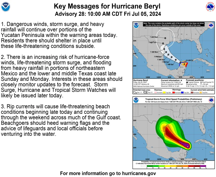
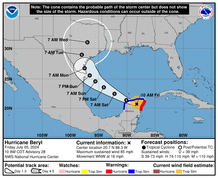
HUNTSVILLE, TX (July 5, 2024) — Hurricane Beryl, currently a powerful storm over the Yucatán Peninsula, poses a significant threat to the Texas coastline in the coming days. With wind speeds currently at 85 mph and potential for re-intensification, Texas residents are urged to prepare for possible impacts including strong winds, heavy rainfall, and storm surge.
Current Situation: Hurricane Beryl made landfall on the Yucatán Peninsula, weakening slightly but is expected to regain strength once it moves over the Gulf of Mexico. The National Hurricane Center forecasts that Beryl will continue its west-northwest trajectory before potentially turning northward towards Texas due to atmospheric conditions.
Historical Context: Hurricane Beryl has a history of causing significant damage. In its previous encounters, Beryl has brought destructive winds, heavy rainfall, and storm surge to various regions, emphasizing the importance of preparation and caution for those in its path.
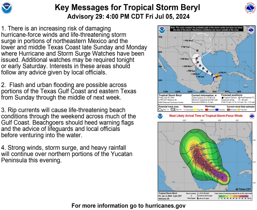
Impacts on Texas: Texas is bracing for Beryl's potential landfall late Sunday or Monday. The National Hurricane Center warns of life-threatening storm surge, hurricane-force winds, and heavy rainfall, particularly along the lower and middle Texas coast. Residents in these areas should stay informed with the latest updates and heed any evacuation orders or warnings from local authorities.
The storm's exact path remains uncertain, but models indicate a high likelihood of significant impact. Texans are advised to secure property, stock emergency supplies, and follow guidance from emergency management officials.
For real-time updates and more information, visit the National Hurricane Center.
